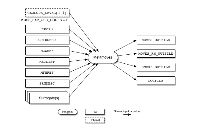
Figure 6.7, “Met4moves input and output files” shows the input and output files for the Met4moves program. The input files are the Grid Description File from MCIP(GRIDDESC), the Surrogate Description file (SRGDESC), the MCIP List of Meteorology File (METLIST), and the representative county cross-reference file (MCXREF).
Met4moves outputs datasets for SMOKE that contain the daily gridded min/max temperatures and averaged RH. Met4moves outputs for MOVES datasets that provide all (min/max) temperature combinations for a representative county, reflecting all min/max combinations for all inventory counties in that county group. The associated RH values are also included in these datasets. In addition, the datasets include the 24-h diurnal profiles needed for the RPP emission process, and contain user-specified temperature increments for use by MOVES.
| File Name | Format | Description |
|---|---|---|
COSTCY |
ASCII | Country, state, county codes file, with time zones |
GEOCODE_LEVEL[1-4] |
ASCII | Geographical level codes and descriptions for gridded inventories, only when USE_EXP_GEO_CODES is set to Y, (COSTCY is ignored
when GEOCODE_LEVEL[1-4] files are used)
|
GRIDDESC |
ASCII | Modeling Domain Grid Description File |
MCXREF |
ASCII | Representative county cross-reference file; NOTE: The list of counties in the MCXREF file used by Met4moves must match the list of inventory counties used by SMOKE |
METLIST |
ASCII | A list of meteorology files containing temperature, mixing ratio, and surface pressure data created by Metcombine |
MFMREF |
ASCII | Representative county fuel monthcross-reference file; NOTE: The list of counties in the MFMREF file used by Met4moves must match the list of inventory counties used by SMOKE |
SRGDESC |
ASCII | Surrogate Description File |
Surrogate File(s) |
ASCII | Surrogate file(s) selected by SRG_LIST |
-
STDATE: [default: 0]This environment variable sets the overall episode start date: Julian format (YYYYDDD) for Movesmrg.
-
ENDDATE: [default: 0]Sets the overall episode end date; Julian format (YYYYDDD).
-
ENDTIME: [default: 230000] -
USE_EXP_GEO_CODES: [default: N]If set to Y then use GEOCODE_LEVEL[1-4] files instead of the COSTCY file to define expanded geographical detail such as country-level(GEOCODE_LEVEL1), country/state-level (GEOCODE_LEVEL2), country/state/county-level (GEOCODE_LEVEL3) or country/state/county/tribal-level (GEOCODE_LEVEL4).
-
PD_TEMP_INCREMENT: [default: 5]Defines the temperature increment (in deg. F) for RPD lookup table to create combinations of min/max temperature bins
-
PH_TEMP_INCREMENT: [default: 5]Defines the temperature increment (in deg. F) for RPH lookup table to create combinations of min/max temperature bins
-
PV_TEMP_INCREMENT: [default: 5]Defines the temperature increment (in deg. F) for RPV lookup table to create combinations of min/max temperature bins
-
PP_TEMP_INCREMENT: [default: 10]Defines the temperature increment (in deg. F) for RPP lookup table to create combinations of min/max temperature bins
-
MIN_NO_RH_BY_TEMPBIN: [default: 1]Defines the minimum number of data point for computing averaged RH by tempearature bin
-
SPECIFIC_HUMIDITY_YN: [default: N]Defines whether compute specific humidity instead of relative humidity
-
SRG_LIST: [default: N]Specifies the code(s) of the spatial surrogate(s) to be used in selecting the grid cells for the county (example: setenv SRG_LIST '100,230').
-
SRGPRO_PATH: [default: N]Defines the location of spatial surrogate files.
-
TEMP_BUFFER_BIN: [default: 0.0]Defines the temperature buffer value (°F). This value will allow Met4moves to expand the min/max temperature range for MOVES RPP processing. If
TEMP_BUFFER_BINis set to 10.0, the original max temperature which is 90.0°F will be treated as 100.0°F, and minimum temperaure (=30°F) will be treated as 20.0°F internally in Met4moves. -
TVARNAME: [default: TEMP2]Specifies the variable name for the temperature to extract from the Met4moves output file (
MOVES_OUTFILE).
| File Name | Format | Description | |
|---|---|---|---|
| MOVES_OUTFILE | ASCII | Contains the absolute minimum and maximum temperatures and average RH values and the 24 hour temperature profiles associated with each representative county (example filename: MOVES_12km_2009091-2009120.txt) | |
| MOVES_RH_OUTFILE | ASCII | Contains the representative county-specific average RH, minimum and maximum temperature by temperature bin and fuel month. | |
| SMOKE_OUTFILE | ASCII | Contains gridded daily min/max temperatures in local timei for RPP mode run in Movesmrg | |
LOGFILE |
ASCII | Log generated from executing Met4moves |