1. The FEST-C System
1.1 Introduction
The Fertilizer Emission Scenario Tool for CMAQ (FEST-C) (http://www.cmascenter.org/fest-c/) is a Java-based interface system that facilitates the integration of agriculture, atmosphere, and hydrology simulations at large scales. With an adapted Environmental Policy Integrated Climate (EPIC) model (http://epicapex.tamu.edu/ epic/) for grassland and crop production, the system is primarily used to simulate daily soil carbon (C), nitrogen (N), and phosphorus (P) cycles on agricultural lands with atmospheric conditions and management practices including fertilization and irrigation. The FEST-C interface with simple tool buttons guides users through EPIC simulations and output extractions to generate the required input for bidirectional NH3 modeling performed using the Community Multiscale Air Quality (CMAQ) modeling system (http://www.cmascenter.org/cmaq/). In addition to its application for air quality modeling, the system has been enhanced to integrate with the Soil and Water Assessment Tool (SWAT, https://swat.tamu.edu/) for watershed hydrological simulations. FEST-C enables the extraction of SWAT-ready input files with nutrients and water runoffs from agricultural lands and weather and N deposition from atmospheric models for simulating nitrogen fate and transport in watersheds. The FEST-C system is developed by EPA scientists, Institute for the Environment at the University of North Carolina at Chapel Hill (UNC), and Benson Consulting with the help from the Texas A&M AgriLife Research. UNC and Benson Consulting were supported under contract to the U.S. EPA Office of Research and Development.
The EPA EPIC implementation requires no previous estimates of fertilizer application; it estimates daily soil N conditions with fertilizer applications based entirely on simulated plant demand in response to local soil and weather conditions. The FEST-C interface associates EPIC simulations spatially to the CMAQ domain covering the conterminous United States (CONUS) and resolution through the current release of the Spatial Allocator (SA) Raster Tools system (http://www.cmascenter.org/sa-tools/) that has been developed under the Community Modeling and Analysis System (CMAS) Center. Figure 1 displays the process diagram of FEST-C linkage with the Weather Research and Forecasting (WRF, http://www2.mmm.ucar.edu/wrf/users/), CMAQ, and SWAT modeling systems. The Biogenic Emissions Landcover Database version 4 (BELD4), which is generated using the BELD4 tool in the SA Raster Tools system, is consistently used in the FEST-C system as well as the WRF/CMAQ modeling system. Previous WRF/CMAQ system results provide daily weather inputs and N deposition (optional), to the FEST-C system. In return, FEST-C generates soil properties (e.g. texture, moisture, and pH) and daily ammonium and nitrate N pool status for specific crops assigned to agricultural land areas in each of the CMAQ bidirectional NH3 modeling grids. With the integrated land-air-water models, FEST-C can be used in assessing not only the impacts of agricultural fertilization and management practices on water quantity and quality, air quality (NH3), and climate (N2O), but also the impacts of meteorology/climate and air quality (N deposition) on crop yield, soil erosion, watershed hydrology and quality, and overall C-N-P biogeochemical status of the agricultural ecosystem.
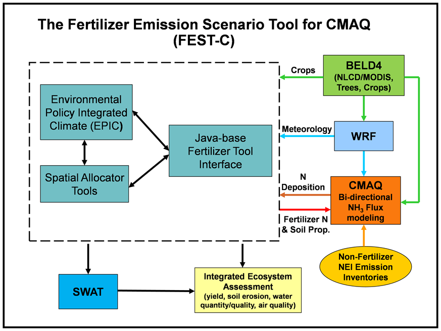
Figure 1. The FEST-C process diagram. The system works for any domains covering the CONUS and for any of the four WRF projections (longitude/latitude, Lambert Conformal Conic, Universal Polar Stereographic, and Mercator).
FEST-C is designed to be used for CMAQ domains in North America, particularly for domains covering CONUS. The current version of the EPIC system for CMAQ has complete modeling capabilities for grids located within the U.S. To apply this system to other regions, users must modify the databases (particularly for soil) that were created within the FEST-C system and to change the agricultural management file generation, as different regions will likely have different agricultural management practices in addition to different soil properties. For areas outside the U.S., the bidirectional CMAQ internally estimates these inputs for regions in Canada and Mexico. The system works for domains at different resolutions and in any of the four WRF projection coordinate systems: longitude/latitude, Lambert Conformal Conic, Universal Polar Stereographic, and Mercator.
1.2 Components
The version 1.4 release of the FEST-C system (FEST-C v1.4), which includes Java interface programs, EPIC FORTRAN codes, and associated data sets, was developed for Linux-based operating systems. The FEST-C Java interface is licensed under the Gnu Public License (GPL) version 3. The downloaded FEST-C system contains the following two directories:
· festc – contains the Java-based interface.
· epic – stores EPIC model version 0509, which has been modified to meet CMAQ input requirements; and related utilities and data for FEST-C v1.4. The original EPIC model description can be obtained from the Texas A&M AgriLife Research web site (http://epicapex.tamu.edu/files/2013/02/epic0509usermanualupdated.pdf ). The documentation of the modified EPIC modeling system for CMAQ is included in the release of the FEST-C system. It provides detailed information on how this particular application of EPIC was developed.
The FEST-C system requires that the SA Raster Tools system be installed on the same computer system where FEST-C resides. For visualization, users can configure FEST-C to view NetCDF files using the Visualization Environment for Rich Data Interpretation (VERDI) or NCVIEW. Both the SA Raster Tools and the VERDI system and their documentation can be obtained from the CMAS web site (https://www.cmascenter.org/).
1.3 Installation and Requirements
Users need to untar the obtained FEST-C and SA packages in their system from the CMAS Center Software Clearinghouse, https://www.cmascenter.org. The programs under FEST-C do not need any compiling, as the system comes with static compiled tools. The Raster Tools under SA, which are required by FEST-C, are not statically pre-compiled with the package. Depending on the system configuration, users may need to recompile the SA Raster tools if there is a library call error when running the tools using FEST-C. Assuming the downloaded FEST-C system is installed under the ${FESTC_HOME} directory and the Spatial Allocator is installed under the ${SA_HOME} directory, users should perform the following steps:
1. Modify ${FESTC_HOME}/festc/config.properties to set:
· work.dir – working directory for scenarios.
· epic.home – epic home directory, which should be ${FESTC_HOME}/epic; includes common data and executables for both EPIC and utilities.
· sa.home – installed Spatial Allocator directory, which should be ${SA_HOME}.
· visual.program.home – directory containing VERDI program.
· queue.cmd – queue job submission command such as qsub or bsub. Queue configuration (includes queue.name and queue.bigmem as well) for job submission has to be modified based on the user’s Linux system. Comment out (place # sign in the front) the three queue configurations if user’s systems do not have batch job queuing systems.
· queue.name – queue name.
· queue.bigmem – big memory setup to be used by the EPIC-to-CMAQ tool.
· debug – set to “true” to print out debug message. It is recommended that users not change this setting.
· allow.diff.check – set to “true” for checking consistent input in "Minimum Crop Acres" and "Fertilizer Year" fields from different subinterfaces. It is recommended that users not change this setting.
2. Make a directory called “festc” under the user’s home directory, which is assumed to be ${USER_HOME}, then copy ${FESTC_HOME}/config.properties to the ${USER_HOME}/festc directory. Change the work.dir setting if needed.
3. Modify ${FESTC_HOME}/festc/festc.sh file to set:
· FESTC_HOME to ${FESTC_HOME}/festc.
· -Xmx1024M to -Xmx2048M (optional) if users want to use 2 GB of RAM to run the interface.
· JAVA path (optional) if users do not want to use the Standard Edition Runtime Environment (JRE) version 8 for Linux 32-bit and 64-bit systems that is included in the FEST-C release.
4. Modify ${FESTC_HOME}/festc/festc_setup.csh to:
· Set the ${FESTC_HOME} and ${SA_HOME} directories.
· Source the file in the user’s .cshrc file.
5. Launch FEST-C 1.4 interface by typing:
· Type festc in any directory with the x-window capability.
Troubleshooting for the SA Raster Tools:
The SA Raster Tools have compiled tools which are stored under ${SA_HOME}/bin/64bits. The executable tools may not work depending on the system configuration. If there is a library error in running the SA Raster Tools within FEST-C, users should:
· Recompile all libraries under ${SA_HOME}/src/libs following instructions in the ${SA_HOME}/src/libs/README file.
· Modiy ${SA_HOME}/src/raster/Makefile for correct paths.
· Type “make clean” to clean previous compiled programs.
· Type “make” to compile the tools.
· Type “make -B install” or “make install” to install compiled tools.
1.4 Interface Launch
The FEST-C interface facilitates the creation of the spatial associations, input files, soil initialization, and application processes required by EPIC. After preliminary site information and soils are assigned to each grid cell, a 25-year “spin-up” simulation is required to generate initial soil and annual nitrogen demand conditions that represent the management system the user has defined. These initial conditions are provided to the year-specific application and management scheme. To launch the FEST-C interface system, type:
· festc or ${FESTC_HOME}/festc/festc.sh
The FEST-C interface allows the user to create, select, and manage different scenario management schemes under the File menu for EPIC modeling and sub-interface tools (see Figure 2).
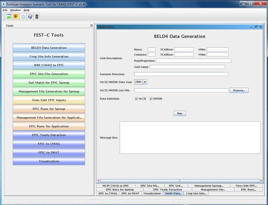
Figure 2. The FEST-C interface system.
The system is described in detail in the remaining sections of this document:
- Section 2: File Structures for EPIC Modeling
- Section 3: Scenario Management Selections under the File Menu
- Section 4: The Pre-EPIC File Generation Tools
1. BELD4 Data Generation
2. Crop Site Info Generation
3. WRF/CMAQ to EPIC
- Section 5: EPIC Spin-up Run Tools:
1. EPIC Site File Generation
2. Soil Match for EPIC Spin-up
3. Management File Generation for Spin-up
4. View/Edit EPIC Inputs
5. EPIC Runs for Spin-up
- Section 6: EPIC Application Run Tools
1. Management File Generation for Application
2. EPIC Runs for Application
- Section 7: Output Processing and Visualizing Tools:
1. EPIC Yearly Extraction
2. EPIC to CMAQ
3. EPIC to SWAT
4. Visualization
· Section 8: Future Work
2. File Structures for EPIC Modeling
The EPIC model and related utilities and data are stored under the ${FESTC_HOME}/epic directory. The working directory, which is named “scenarios”, is defined by work.dir in the user’s config.properties file. In the released tar, “scenarios” with a sample “test_case” scenario is provided for users to test the system under the epic directory. After the installation, users can move the “scenarios” directory to their working space and modify the work.dir entry for the new location. The file structure for EPIC modeling within the FEST-C system is displayed in Figure 3.
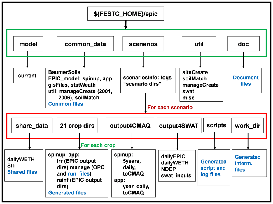
Figure 3. File structure for EPIC modeling (directory names in black and files in blue)
The epic directory contains four subdirectories: model, util, common_data, and doc; scenarios is under work.dir, which is specified in config file under home directory. These are described below.
· model – used to store the EPIC0509 model for FESTCv1.4. It includes one subdirectory:
- current: contains two EPIC models for spin-up and application simulations modified from EPIC0509 for CMAQ modeling. The EPIC0509 with many updates were obtained from the Texas A&M AgriLife Research.
· doc – contains the documentation on the development of the EPIC modeling system for CMAQ (EPA_EPIC_application_v1_10252013.pdf).
· util – contains utility programs developed by Benson Consulting to generate site, soil, and management input files required by EPIC. It has four subdirectories:
- siteCreate: contains two programs used by the EPIC Site File Generation tool. The programs will not only generate EPIC site files but also link EPIC sites (grid cell centroids) to the BELD4 crop grid assignments and the 8-digit hydrologic cataloging units (HUCs) that contain the grid cells to be used in the soil matching program. Based on BELD4, this program assigns only those crops to a grid cell that BELD4 indicates are present at that location. This minimizes the number of crop-specific simulations performed across large domains. Users need to input the minimum crop acres, usually 0 or 40 acres, but can be any value, to be included in EPIC simulations. The larger the cropland area minimum, the fewer crops that will be identified within a grid for EPIC, the fewer the grid-level simulations and the faster the overall system execution time.
- soilMatch: contains six soil matching programs used by the Soil Match for EPIC Spinup tool. Soils are selected based on the U.S. Department of Agriculture (USDA) 1997 Natural Resource Inventory (NRI) assignment of each crop in each 8-digit HUC to its most common HUC-8 soil type.
- manageCreate: contains programs to create EPIC management files for spin-up and application simulations by the Management File Generation for Spinup and Management File Generation for Application tools.
- swat: contains R codes and associated sample c-shell scripts to extract daily EPIC outputs, nitrogen deposition, and daily weather and to transfer them to SWAT input by clicking “EPIC”, “NDEP”, “DailyWETH”, and “SWAT INPUTS” sequentially. “SWAT INPUTS” is the last button users should click for aggregating all input data generated from the first three buttons into SWAT input format. The tool associated with “SWAT INPUTS” button requires a text file including delivery ratios for EPIC to SWAT integration. The sample text file is provided in the “share_data” directory under the test_case scenario as “subbasins-mapping_test_case.csv”. Users need to create this file for their corresponding watershed SWAT simulations.
- misc: contains utility programs for converting the generated BELD4 land use file in NetCDF format to be in IO/API format for the CMAQ bi-directional modeling (used by the BELD4 tool script), aggregating EPIC variables from yearly average extraction output by regions (e.g. 8-digit hydrologic units, states, counties, and the whole domain) and by crops (e.g. 42 crops), summarizing N fertilizer application from extracted daily files for CMAQ, and generating files with selected EPIC daily output variables for the 8-digit HUC areas. Users can access the README file in the directory and modify the C shell scripts in the subdirectories to use the tools. Users must have the required R libraries installed to run the R tool utilities.
· common_data – contains data sets needed for EPIC and utility programs. Also provided under this subdirectory is the file EPIC_42crop_names.txt, which contains the crop names and numbers, used in the FEST-C system. This directory has the following subdirectories:
- BaumerSoils: contains the soil data sets (22,838 soils) built with soil parameters from the Baumer database developed by Dr. Otto Baumer of National Soil Survey Laboratory (NSSL) at USDA. Dr. Baumer used the SOILS5 database and soil pedon data to develop the representative EPIC data sets. Benson Consulting utilized this information to create a subset of soil parameters in 22,838 soil files to be used with EPIC. Detailed information on the data set creation can be obtained from the documentation of the EPIC modeling system for CMAQ. The raw soil profiles have been QA’d and missing descriptors have been filled so that they may be similar, but are not identical to the profiles available through the USGS STATSGO and SURRGO databases.
- EPIC_model: contains two 5-year average CMAQ N deposition daily and NetCDF files and the following two directories, which have common data files required by EPIC spin-up and application runs. The two 5-year average N deposition daily files under dailyNDep_2004 and dailyNDep_2008 directories provide 5-year average CMAQ-simulated N deposition estimates for each calendar day over the periods 2002-2006 (referred to as “2002-2006 5-year CMAQ average” and 2006-2010 (referred to as “2006-2010 5-year CMAQ average”. These periods are provided to reflect the documented non-stationarity of N deposition trends. The average N deposition data are from the U.S. CMAQ domain which has the following properties:
GRID_PROJ "+proj=lcc +a=6370000.0 +b=6370000.0 +lat_1=33 +lat_2=45 +lat_0=40 +lon_0=-97"
GRID_ROWS 299
GRID_COLUMNS 459
GRID_XMIN -2556000.0
GRID_YMIN -1728000.0
GRID_XCELLSIZE 12000.0
GRID_YCELLSIZE 12000.0
The N deposition data from the nearest grid point in the average daily sets is selected in EPIC simulations.
· spinup – has common files used for EPIC spin-up simulations. For all crops except potatoes, the spin-up is set to run for 25 years using the EPIC statistical weather generator (see the weather generator discussion in the EPIC documentation from the Texas A&M AgriLife Research). We have arbitrarily set the starting year as 1978 in EPICCONT.DAT. The termination date is not used by any subsequent codes and, since the driving data are statistically generated, do not exactly correspond to any observation year. For potatoes, the spin-up is set to run for 100 years from 1903 in EPICCONT_POTATOES.DAT.
· app – contains common files used for EPIC application simulations. In the FEST-C system, users input the target year (1 year only) for the EPIC application simulation. When a new scenario is created, EPICCONT.DAT from this directory is copied to the scenarios/“scenario name”/share_data directory and the simulation period is changed to 2 years starting from the year previous to the simulation year. Two years’ worth of weather data are needed to support production of fall-sown crops. At present, the same weather is used for both years. In the future, an option may be added to support input of two unique weather time series.
- gisFiles: includes U.S. counties, U.S. states plus some boundary areas in Canada and Mexico, U.S. 8-digit HUC shapefiles, and elevation and slope raster files. The readme file in the directory describes each file and associated attributes in detail.
- statWeath: contains weather station climate statistics files distributed with the standard EPIC package.
- util: includes common files used by the utility programs. This directory has two subdirectories:
· soilMatch – has input files used by the soil matching program to create EPIC soil files for the EPIC Runs for Spinup tool.
· manageCreate – contain files to be used in generating EPIC spin-up and application management files. We developed management data with fertilizer types applied in 2001 and 2006 for each of 10 production regions (Northeast, Appalachia, Southeast, Lake States, Corn Belt, Delta States, Northern Plains, Southern Plains, Mountain, and Pacific) (see the region map in Cooter et al. [2012], which is listed in the “Online Resources” section of the FEST-C web site (http://www.cmascenter.org/fest-c/). Fertilizer types (but not amounts) applied are based on fertilizer sales of 62 major fertilizer types by state. Users can obtain detailed information from the documentation for the EPIC modeling system for CMAQ. It is recommended that 2001 be used for applications prior to 2006, and that 2006 be used for applications from 2006 through 2010. We anticipate that a 2011 fertilizer type file will be included in the next interim release. Fertilizer types applied are used by the EPIC management file generation for application, and they are stored under the following two subdirectories:
- 2001: for 2001 fertilizer year management file generation.
- 2006: for 2006 fertilizer year management file generation.
In both cases, regional fertilizer data information is stored under the directory:
- regionFert
· scenarios – contains EPIC application scenarios and it is the working directory for a user. The directory is described separately below this bulleted list.
In general, users should not change the data files described in the above directories. All files generated by users’ applications are stored under the scenarios directory. When the user creates a scenario by selecting “New Scenario” under the File menu, the following items are created:
· scenariosInfo – a metadata file that stores information for the created scenario, which is assumed to be named by the user as “scenario name”. This directory contains:
- “scenario name”: an XML file that stores the scenario information.
- logs: directory containing the script file used to create (or copy or delete as well) the scenario and execution log file.
· “scenario name” – scenario directory that will contain all generated files for this scenario.
Under each scenario directory, the following directories are created for EPIC modeling:
· share_data – contains all data sets generated for EPIC modeling and to be used by all crops modeled. The following two data subdirectories which store generated EPIC site files and daily weather files are included under this directory:
- SIT: contains EPIC site files.
- dailyWETH: contains daily weather and N files for EPIC modeling.
· scripts – stores script and log files created to run the tools within the FEST-C interface. All tools are executed through the Linux queue system. Users should always check the log file to make sure that the queue job completed correctly. Unwanted files under this directory should be cleaned out periodically.
· work_dir – contains some intermediate or temporary files created by the FEST-C tools. Not many files are created under this directory.
· 21 crop dirs ( "HAY", "ALFALFA", "OTHER_GRASS", "BARLEY", "EBEANS", "CORNG", "CORNS", "COTTON", "OATS", "PEANUTS", "POTATOES", "RICE", "RYE", "SORGHUMG", "SORGHUMS", "SOYBEANS", "SWHEAT", "WWHEAT", "OTHER_CROP", "CANOLA", "BEANS") – the 21 crop directories are created by the EPIC Site File Generation tool. Under each crop directory there are many files that are created for generating EPIC input files. The spinup and app subdirectories described below are also created from management file generation and EPIC runs for spin-up and application:
- spinup: contains files created from the EPIC management file generation and EPIC runs for spin-up tools. It contains the following three subdirectories:
· manage – contains EPIC run files, EPIC site management files created by the Management File Generation for Spinup tool, and tile drain soil list file. The management files and tile drain soil list file are contained under the following subdirectories:
- OPC: contains the management schedule for each domain grid cell containing rain-fed and irrigated crop. Variables (schedule) can be interpreted using the documentation for the EPIC modeling system for CMAQ.
- tileDrain: contains the SOILLIST.DAT which has soil tile drain information for EPIC spinup runs. In general, if a soil is classified as hydric, then it is assumed to drain.
· rainf – contains files for each domain grid cell that are created by the EPIC Runs for Spinup tool from rain-fed crops. It contains the following output directories (see the EPIC documentation from the Texas A&M AgriLife Research):
- DFA: daily fertilizer and other output.
- NCM: monthly fertilizer and other output.
- NCS: monthly soil output.
- OUT: standard EPIC output file that contains various budget tables and summaries of the simulation which are useful for debugging.
- SOL: soil output files that are used as initial values for the application.
- TNA: annual fertilizer and other outputs.
- TNS: annual soil output.
· irr – contains files for each domain grid cell containing the particular crop that were created by the EPIC Runs for Spinup tool from irrigated crops. It contains the following output directories:
- DFA: daily fertilizer and other output.
- NCM: monthly fertilizer and other output.
- NCS: monthly soil output.
- OUT: standard EPIC output file that contains various budget tables and summaries of the simulation that are useful for debugging.
- SOL: soil output files.
- TNA: annual fertilizer and other outputs that are useful for debugging.
- TNS: annual soil output.
- app: contains files created from the management file generation and EPIC runs for application tools. It contains the following three subdirectories:
· manage – contains EPIC run files, EPIC site management files created by the Management File Generation for Application tool, and tile drain soil list file. Management files and the tile drain soil list file are contained under the following subdirectories:
- OPC: contains the management schedule for each domain grid cell containing rain-fed and irrigated crop. Variables (schedule) can be interpreted using the documentation for the EPIC modeling system for CMAQ.
- tileDrain: contains the SOILLIST.DAT which has soil tile drain information for EPIC application runs.
· rainf – contains files created by the EPIC Runs for Application tool from rain-fed crops. It contains the following output directories (see the EPIC documentation from the Texas A&M AgriLife Research):
- DFA: daily fertilizer and other output.
- NCM: monthly fertilizer and other output.
- NCS: monthly soil output.
- OUT: standard EPIC output file that contains various budget tables and summaries of the simulation (useful for debugging).
- SOL: soil output files.
- TNA: annual fertilizer and other outputs.
- TNS: annual soil output.
· irr – contains files created by the EPIC Runs for Application tool from rain-fed crops. It contains the following output directories:
- DFA: daily fertilizer and other output.
- NCM: monthly fertilizer and other output.
- NCS: monthly soil output.
- OUT: standard EPIC output file that contains various budget tables and summaries of the simulation (useful for debugging).
- SOL: soil output files.
- TNA: annual fertilizer and other output.
- TNS: annual soil output.
· output4CMAQ – stores EPIC output files and extracted NetCDF files for quality assurance (QA) and CMAQ bidirectional NH3 modeling. This directory contains the two following subdirectories:
- spinup: contains all files created from EPIC spin-up simulations for CMAQ. It contains the following three subdirectories:
· 5years – contains extracted average EPIC output for each crop from the last five years of the spin-up simulation. Files are named as “BELD4 Crop Number”.dat (see Table 1 in Section 4.1 for crop numbers).
· daily – stores daily EPIC output files for the EPIC spin-up simulation of each crop. “BELD4 Crop Number”.NCS is for soil output and “BELD4 Crop Number”.NCD is for fertilizer and other daily output.
· toCMAQ – contains created NetCDF and IO/API files with EPIC spin-up output for selected modeling grid cells with crop data. The NetCDF output files are created using the FEST-C tools by extracting data files stored under the 5years or daily directories listed above.
- app: stores files created from EPIC application simulations for CMAQ. It contains the following three subdirectories:
· year – contains extracted average EPIC output for the EPIC application year. Files are named as “BELD4 Crop Number”.dat.
· daily – stores daily EPIC output files for the EPIC application simulation of each crop. “BELD4 Crop Number”.NCS is for soil output and “BELD4 Crop Number”.NCD is for fertilizer and other daily output.
· toCMAQ – contains created NetCDF and CMAQ-ready IO/API files with the BELD4 data and EPIC application simulation results for the modeling domain. The NetCDF output files are created using the FEST-C tools by extracting data files stored under the year or daily directories listed above.
· output4SWAT – stores daily EPIC, N deposition, and meteorology files summarized by regions and SWAT-ready input files for SWAT simulation. This directory contains four subdirectories:
- dailyEPIC – contains runoff data extracted from EPIC daily output files. The extracted data are summarized by the domain, county, state, HUC2, HUC6, and HUC8.
- dailyWETH – contains extracted weather data.
- NDEP – contains extracted nitrogen deposition data.
- swat_inputs – contains SWAT-ready EPIC, weather, and N deposition input files in subdirectories named as dailydep, dailyweath, and EPICinputPoint.
3. Scenario Management Selections under the File Menu
There are five scenario management selections (as well as Exit) under the File menu at the upper left of the FEST-C tool bar: Open Scenario, New Scenario, Copy Scenario, Save Scenario, and Delete Scenario. Each of these is described below.
· Open Scenario – to open an already-created scenario. Users always need to either open or create (see next bullet) a scenario to work on. Users can select any one of the scenarios under the scenarios/scenariosInfo directory. After users open a scenario, information for the scenario, such as the domain description, will be automatically filled in by the FEST-C tool interface. Within the FEST-C system, users have to work within a scenario to execute any of the tools except the Visualization tool. Figure 4 shows the interface used to open the test case created in the FEST-C system (The test_case scenario is described at the beginning of Section 4).
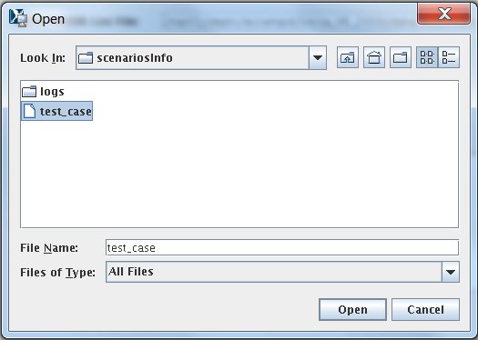
Figure 4. Open Scenario selection window used to open the test_case scenario.
· New Scenario – to create a new scenario (versus opening one that’s already been created). In creating a new scenario, the user has to provide the following information for a CMAQ modeling domain and EPIC simulation year (see Figure 5):
- Rows, Columns: the number of rows and columns for the domain.
- XCellSize, YCellSize: x and y resolution for the grid cell.
- XMin, YMin: x and y coordinates of the lower left corner of the lower left grid cell. Users can often find this information in the GRIDDESC file in the Meteorology-Chemistry Interface Processor (MCIP) output.
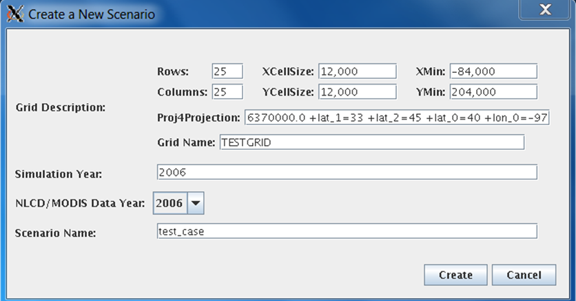
Figure 5. New Scenario selection window with input to create the test_case scenario within FEST-C.
- Proj4Projection: domain projection defined in Proj4 format (see details at http://geotiff.maptools.org/proj_list/). The interface sets the Lambert Conformal Conic projection, which is used by the CMAQ U.S. 12-km domain as the default. Users can change it to any projection supported for CMAQ modeling.
- Grid Name: user-supplied name for the domain, using no more than 16 alphanumeric characters and no spaces.
- Simulation Year: year (YYYY) for the EPIC simulation. FEST-C is designed to simulate yearly fertilizer application information for CMAQ bidirectional NH3 modeling.
- NLCD/MODIS Data Year: year (YYYY) for the NLCD/MODIS land cover data used for the EPIC simulation. NLCD/MODIS land cover data are required in the EPIC simulation within FEST-C for CMAQ bidirectional NH3 modeling. Currently, users can select 2001, 2006, or 2011 NLCD/MODIS data year. 2016 NLCD/MODIS data selection will be added to the system in the future.
- Scenario Name: name for the scenario, using alphanumeric characters and no spaces.
When a new scenario is created, the following files and directories are created:
- scenarios/scenariosInfo/“scenario name”: XML file to store the scenario information.
- scenarios/“scenario name”: directory to store all generated information for this scenario. Some subdirectories are also generated under this scenario directory (see Section 2 for file structures).
- scenarios/“scenario name”/share_data/EPICCONT.DAT: contains EPIC constant parameters. The simulation period is a two-year period starting with the year before the simulation year.
· Copy Scenario – to copy an existing scenario under the scenarios/scenariosInfo directory to a new scenario with a defined simulation year, which can be the same as or different from the existing scenario year (see Figure 6). Note that if the existing scenario contains many crop simulations, this action can take a long time to complete in a background queue job.
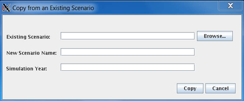
Figure 6. Copy Scenario selection window.
· Save Scenario – to save a scenario after a user has worked on it. Only the input information for the scenario tool interfaces is saved. When the user performs the FEST-C tool actions, generated files are always saved under different directories, described in Section 2.
· Delete Scenario – to delete a scenario. This is also run as a background submission and can take some time. All directories and subdirectories for that scenario are deleted completely.
· Exit – to exit the FEST-C interface. You will be asked if you want to save the scenario you were working on before exiting the tool.
The action performed by making a selection under the File menu (e.g., copy, create, delete) is executed by a script file through the queue job. The script and log files are stored under the scenarios/scenariosInfo/logs directory. Users should check the log files under the directory to make sure that the selected action completely correctly.
4. The Pre-EPIC File Generation Tools
Before describing the various FEST-C tools in Sections 4 through 7, we must first discuss the test_case scenario in the FEST-C system, because we use this scenario to demonstrate the input and output components on the tool interface. The test_case scenario is a small 12-km domain with 25 rows and 25 columns in the CMAQ standard projection. The domain is located in the northwest corner of Iowa and crosses into Minnesota, South Dakota, and Nebraska. Figure 7 illustrates the domain grid cells with the identification numbers (GRIDID) used in the FEST-C system; colors are used to indicate the crop percentage for each grid cell as generated from 2006 NLCD data. All 625 (25´25) 12-km grid cells in this test domain have crop coverage, and most of them have more than 75% crop coverage. The GRIDID for a grid cell with row and column starting from 1 is defined as:
![]() (1)
(1)
where columns is the number of columns for the domain. Row and column start from 1 at the lower left corner cell in the domain. Users can compute the row and column for a grid cell with GRIDID as:
![]() (2)
(2)
![]() (3)
(3)
where floor is for rounding down the value and remainder is for taking the remainder from the division.
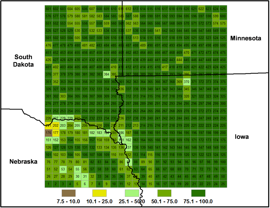
Figure 7. FEST-C test_case scenario 12-km domain in the U.S. northern Central Plains. Associated with each grid cell is an identification number (GRIDID) and a color that indicates crop coverage percentage. The domain’s cells are numbered from 1 for the lower left corner cell to 625 for the upper right corner cell.
In Section 4, we discuss the first three tools in the FEST-C interface: the BELD4 Data Generation tool, the Crop Site Info Generation tool, and the WRF/CMAQ-to-EPIC tool. These are used to prepare site crop and spatial data for EPIC input file generation and to generate required daily weather data and optional nitrogen deposition data for the EPIC simulation year. All three tools were developed in the SA Raster Tools system.
4.1 BELD4 Data Generation
EPIC modeling for a CMAQ domain requires BELD4 data, which are used for selecting grid cells with crop coverage. The BELD4 Data Generation tool allows users to compute the BELD4 dataset for a selected scenario. For detailed information, users can consult the SA Raster Tools documentation: https://www.cmascenter.org/sa-tools/. Figure 8 shows the interface used to compute the BELD4 dataset for the test_case scenario.
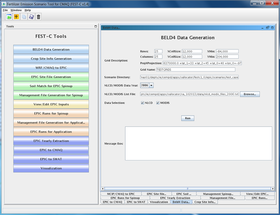
Figure 8. The BELD4 Data Generation tool interface for the test_case scenario.
Before running this tool, users need only to make sure that the following two entries are correct for their scenarios:
· NLCD/MODIS Data Year – the year defined when creating the scenario; it can be either 2001, 2006, or 2011. Processed 2001, 2006, and 2011 crop tables from the U.S. and Canada are stored under the ${SA_HOME}/data directory for this tool. The 42 rain-fed and irrigated crops generated from the BELD4 tool and modeled in the FEST-C system are displayed in Table 1. In addition to crop numbers used in BELD4 (new version of BELD), the table also lists BELD3 (older version) numbers, because we started building the FEST-C system using the BELD3 data. Crop numbers used in EPIC modeling often follow the BELD3 crop numbers (from 22 to 63), but the output files from EPIC modeling for use in CMAQ use the BELD4 crop numbers (from 1 to 42). If a new crop is to be modeled in the FEST-C system, new crop tables under the SA data directory must be generated and the BELD4 tool has to be modified as well. Table 2 provides additional information on how crops are mapped to each EPIC crop type.
Table 1. The 42 rain-fed and irrigated crops modeled in the FEST-C system.
|
BELD4 |
BELD3 |
Crop Name |
BELD4 |
BELD3 |
Crop Name |
BELD4 |
BELD3 |
Crop Name |
|
1 |
22 |
Hay |
15 |
36 |
Cotton |
29 |
50 |
SorghumSilage |
|
2 |
23 |
Hay_ir |
16 |
37 |
Cotton_ir |
30 |
51 |
SorghumSilage_ir |
|
3 |
24 |
Alfalfa |
17 |
38 |
Oats |
31 |
52 |
Soybeans |
|
4 |
25 |
Alfalfa_ir |
18 |
39 |
Oats_ir |
32 |
53 |
Soybeans_ir |
|
5 |
26 |
Other_Grass |
19 |
40 |
Peanuts |
33 |
54 |
Wheat_Spring |
|
6 |
27 |
Other_Grass_ir |
20 |
41 |
Peanuts_ir |
34 |
55 |
Wheat_Spring_ir |
|
7 |
28 |
Barley |
21 |
42 |
Potatoes |
35 |
56 |
Wheat_Winter |
|
8 |
29 |
Barley_ir |
22 |
43 |
Potatoes_ir |
36 |
57 |
Wheat_Winter_ir |
|
9 |
30 |
BeansEdible |
23 |
44 |
Rice |
37 |
58 |
Other_Crop |
|
10 |
31 |
BeansEdible_ir |
24 |
45 |
Rice_ir |
38 |
59 |
Other_Crop_ir |
|
11 |
32 |
CornGrain |
25 |
46 |
Rye |
39 |
60 |
Canola |
|
12 |
33 |
CornGrain_ir |
26 |
47 |
Rye_ir |
40 |
61 |
Canola_ir |
|
13 |
34 |
CornSilage |
27 |
48 |
SorghumGrain |
41 |
62 |
Beans |
|
14 |
35 |
CornSilage_ir |
28 |
49 |
SorghumGrain_ir |
42 |
63 |
Beans_ir |
Table 2. Mapping of the 42 rain-fed and irrigated crops for U.S. and Canada (Mexico will be available in a future release).
|
BELD4 |
Crop Name |
USA |
Canada |
|
1 |
Hay |
HAY- (HAY, ALFALFA)-(HAY, WILD) + HAYLAGE, (EXCL ALFALFA) |
All other tame hay and fodder crops |
|
2 |
Hay_ir |
Same items, irrigated |
N/A |
|
3 |
Alfalfa |
ALFALFA HAY + ALFALFA HAYLAGE |
Alfalfa and alfalfa mixtures |
|
4 |
Alfalfa_ir |
Same items, irrigated |
N/A |
|
5 |
Other_Grass |
(AG LAND, CROPLAND, PASTURED ONLY )-(Hay+Alfalfa) |
N/A |
|
6 |
Other_Grass_ir |
N/A |
N/A |
|
7 |
Barley |
BARLEY |
Barley |
|
8 |
Barley_ir |
BARLEY, irrigated |
N/A |
|
9 |
BeansEdible |
BEANS, DRY EDIBLE, LIMA; BEANS, DRY EDIBLE, (EXCL LIMA) |
Dry white beans; Other dry beans |
|
10 |
BeansEdible_ir |
Same items, irrigated |
N/A |
|
11 |
CornGrain |
CORN, GRAIN |
Corn for grain |
|
12 |
CornGrain_ir |
CORN, GRAIN, IRRIGATED |
N/A |
|
13 |
CornSilage |
CORN, SILAGE |
Corn for silage |
|
14 |
CornSilage_ir |
CORN, SILAGE, IRRIGATED |
N/A |
|
15 |
Cotton |
COTTON |
N/A |
|
16 |
Cotton_ir |
COTTON, IRRIGATED |
N/A |
|
17 |
Oats |
OATS |
Oats |
|
18 |
Oats_ir |
OATS, IRRIGATED |
N/A |
|
19 |
Peanuts |
PEANUTS |
N/A |
|
20 |
Peanuts_ir |
PEANUTS, IRRIGATED |
N/A |
|
21 |
Potatoes |
POTATOES+SWEET POTATOES |
Potatoes |
|
22 |
Potatoes_ir |
Same fractional breakdown of rainfed vs irrigated potatoes from 2006 data |
N/A |
|
23 |
Rice |
N/A |
N/A |
|
24 |
Rice_ir |
RICE, IRRIGATED |
N/A |
|
25 |
Rye |
RYE |
Fall rye |
|
26 |
Rye_ir |
RYE, IRRIGATED |
N/A |
|
27 |
SorghumGrain |
SORGHUM, GRAIN |
N/A |
|
28 |
SorghumGrain_ir |
SORGHUM, GRAIN, IRRIGATED |
N/A |
|
29 |
SorghumSilage |
SORGHUM, SILAGE |
N/A |
|
30 |
SorghumSilage_ir |
SORGHUM, SILAGE, IRRIGATED |
N/A |
|
31 |
Soybeans |
SOYBEANS |
Soybeans |
|
32 |
Soybeans_ir |
SOYBEANS, IRRIGATED |
N/A |
|
33 |
Wheat_Spring |
WHEAT, SPRING, DURUM; WHEAT, SPRING, (EXCL DURUM) |
Spring wheat (excluding durum); Durum wheat |
|
34 |
Wheat_Spring_ir |
WHEAT, SPRING, DURUM, IRRIGATED; WHEAT, SPRING, (EXCL DURUM), IRRIGATED |
N/A |
|
35 |
Wheat_Winter |
WHEAT, WINTER |
Winter wheat |
|
36 |
Wheat_Winter_ir |
WHEAT, WINTER, IRRIGATED |
N/A |
|
37 |
Other_Crop |
(AG LAND, CROPLAND) - (AG LAND, CROPLAND, PASTURED ONLY) -sum of rainfed crops
If “AG LAND, CROPLAND” is larger |
Mixed grains; Spring rye; Flaxseed; Forage seed for seed; Mustard seed; Sunflowers; Canary seed; Ginseng; Buckwheat; Sugar beets; Caraway seed; Triticale; Other field crops |
|
38 |
Other_Crop_ir |
Irrland= (AG LAND, (EXCL HARVESTED CROPLAND), IRRIGATED – ACRES) + (AG LAND, CROPLAND, HARVESTED, IRRIGATED – ACRES) =Irrland – sum of irr crops (if irrland is larger) |
N/A |
|
39 |
Canola |
CANOLA |
Canola (rapeseed) |
|
40 |
Canola_ir |
CANOLA, IRRIGATED |
N/A |
|
41 |
Beans |
PEAS, DRY EDIBLE |
Dry field peas; Lentils; Chick peas |
|
42 |
Beans_ir |
PEAS, DRY EDIBLE, IRRIGATED |
N/A |
· NLCD/MODIS List File – set to the fixed-format text file that contains downloaded NLCD land use, imperviousness, and canopy data files and downloaded tiled MODIS land cover (MCD12Q1) data sets. The interface sets the file ${SA_HOME}/data/ nlcd_modis_files_{NLCD/MODIS Data Year}.txt as the default file. Users need to download NLCD and MODIS land cover data sets and modify the text file accordingly using the paths and names for the downloaded data sets. The text file must have the same fixed titles and format as in the default file. ${SA_HOME}/data/sat/README contains instructions on downloading the data sets. If users want to generate a 2001 BELD4 data set, 2001 NLCD and MODIS land cover data sets have to be downloaded from the NLCD web site (https://www.mrlc.gov/finddata.php) and MODIS land products web site (https://lpdaac.usgs.gov/products/modis_products_ table/mcd12q1 ), and the nlcd_modis_files_2001.txt list file has to be modified following the format in this sample file.
When the Run button on the BELD4 Data Generation tool interface is clicked, a c-shell (csh) script file is generated under the scenarios/”scenario name”/scripts directory. This file is submitted to the system as a queue job after the user clicks OK, and a log file for the job execution will be generated after the queue job is finished. Users should always check for error messages in the log file, based on the information provided in the Message Box (shown in Figure 8).
The outputs produced by the tool are the following files, which are stored under the ”scenario name”/share_data and ”scenario name”/output4CMAQ/app/ toCMAQ directories:
· beld4_{Gird Name}_{NLCD/MODIS Data Year}.nc (beld4_TESTGRIDS_2006.nc for the test_case scenario) – both NetCDF and I/O API formatted files containing gridded percentage data for imperviousness, canopy, 194 tree species, 40 NLCD/MODIS land cover classes, and 42 BELD4 crops are created. The NetCDF domain- and resolution-specific data file is a required input to the Crop Site Info Generation tool discussed in the next section. CMAQ bi-directional NH3 modeling requires the I/O API formatted BELD4 output file under the ”scenario name”/output4CMAQ/app/toCMAQ directory.
· beld4_{Grid Name}_{ NLCD/MODIS Data Year}.txt (beld4_TESTGRIDS_2006.txt for the test_case scenario) – a text table containing gridded percentage data for imperviousness, canopy, and 40 NLCD/MODIS land cover classes for a specific domain and grid resolution.
4.2 Crop Site Info Generation
The Crop Site Info Generation tool is used to compute EPIC site (grid cells) and crop information for EPIC modeling. The tool processes spatial boundary shapefiles and elevation and slope image data to generate site information data needed in EPIC modeling. Figure 9 displays the tool interface used to compute the crop site information for the test_case scenario. The tool uses the spatial data sets stored under ${FESTC_HOME}/epic/common_data/gisFiles and input files from the ${SA_HOME}/data directory. Before running this tool, users need only to choose the following two entries for this tool:
· BELD4 NetCDF File – this is the BELD4 NetCDF file generated using the BELD4 tool described above. The file name should be of the form beld4_{Gird Name}_{NLCD/MODIS Data Year}.nc (e.g. beld4_TESTGRIDS_2006.nc for the test_case scenario). If this file does not exist, the interface will indicate this after Run is clicked. If this is the case, users need to either run the BELD4 tool to generate this data set or input anywhere within the computer system a BELD4 NetCDF file that is based on the same domain as the domain of the scenarios with which the users are working.
· Minimum Crop Acres – this is the minimum crop area for at least one of the 42 possible crops in a grid cell, if the grid cell is to be selected for EPIC simulation. For instance, users can set it to be 40 acres for representing the smallest commercially viable farm size. For finer grid resolutions or for domains in which smaller commercial enterprises make up a significant fraction of farms (e.g., orchards, some vegetable and specialty crops), users may need to reduce this minimum to adequately characterize the distribution of agricultural lands. For including all cropland in simulations, users should set it to be 0.0. Doing so may increase the number of simulated grid cells (sites), which can also increase run time.
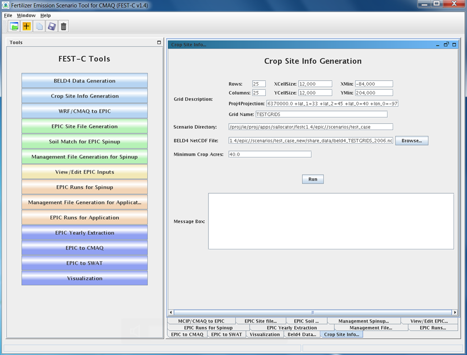
Figure 9. The Crop Site Info Generation tool interface used for the test_case scenario.
After Run has been clicked and the queue job has completed, users should check the log file under their scenario’s scripts directory to see whether any errors occurred during execution. The tool generates the following three text output files stored under scenarios/”scenario name”/share_data:
· EPICSites_Info.csv – contains the GRIDID, XLONG, YLAT, ELEVATION, SLOPE_P, HUC8, REG10, STFIPS, CNTYFIPS, GRASS, CROPS, CROP_P, COUNTRY, and COUNTRY-PROVINCE items used for creating EPIC site files.
· EPICSites_Crop.csv – contains the GRIDID, acreages of 42 possible crops within each grid cell, COUNTRY, and HUC8 items used in EPIC site and soil file generation.
· allSites_Info.csv – contains the GRIDID, XLONG, YLAT, ELEVATION, SLOPE_P, HUC8, REG10, STFIPS, CNTYFIPS, GRASS, CROPS, CROP_P, COUNTRY, and COUNTRY-PROVINCE items for all grid cells to be used in the SWAT watershed extraction.
4.3 WRF/CMAQ to EPIC
The WRF/CMAQ-to-EPIC tool is used to generate EPIC daily weather data and, if the option is selected, N deposition inputs to be used in EPIC application simulations. The tool reads EPIC grid cell information stored in the allSites_Info.csv file generated using the Crop Site Info Generation tool (the previous tool). It extracts daily weather input data from WRF simulation output (METCOR2D data arrays) into a NetCDF file and EPIC-ready text files. Users need to make sure that the right version of the WRF/CMAQ-to-EPIC tools are compiled under the Spatial Allocator. There are two versions of this tool: one for CMAQ before version 5.2 and one for CMAQ v5.2 or above version.
There are up to four options currently available for the inclusion of daily atmospheric deposition data in EPIC simulations: (1) no N deposition, (2) the original EPIC default (assumes a constant N concentration of 0.8 ppm in precipitation and no dry deposition), and (3) CMAQ hourly output files (DRYDEP, WETDEP1) from a previous CMAQ run (unidirectional or bidirectional), and (4) a pre-processed set of 5-yr average CMAQ deposition estimates for the period 2002-2006 (labeled as 2004) and 2006-2010 (labeled as 2008). In the vicinity of areas receiving significant atmospheric dry deposition, such as areas immediately surrounding large animal feeding operations, this information can impact EPIC biogeochemistry and subsequent estimates of plant N application needs. If speciated N deposition is available, oxidized wet and dry deposition are assumed to enter the EPIC soil nitrate pool, and reduced wet and dry deposition is assumed to enter the EPIC soil ammonium pool. If CMAQ hourly output files are selected for this tool, the MCIP and CMAQ domains must be the same as the domain defined in the EPIC scenario. Figure 10 shows this tool interface as used for the test_case scenario.
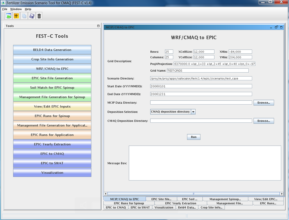
Figure 10. The WRF/CMAQ-to-EPIC tool interface used for the test_case scenario.
Before running this tool, users must provide input for the following three items in the interface:
· MCIP Data Directory – this directory contains processed WRF files output by MCIP for the EPIC simulation year. This tool requires only MCIP METCRO2D output files. METCRO2D output files must have names of the format METCRO2D*{DATE} in which * can be any non-digit characters and {DATE} can be in one of four date formats: YYYYMMDD, YYMMDD, YYYYDDD, or YYDDD (e.g., METCRO2D_051226)
· Deposition Selection – used to select one of the following three options:
- CMAQ deposition directory: select this option to use CMAQ deposition output files. If this is selected, users must set the CMAQ deposition file directory in the next field on the interface.
- Default: this option assumes that the N mixing ratio is 0.8 ppm for wet oxidized N deposition. The tool computes wet oxidized N deposition based only on WRF rainfall, and other N deposition variables are assumed to be zero.
- Zero: this option assumes that there is no atmospheric N.
· CMAQ Deposition Directory – used to set the directory containing the CMAQ dry and wet deposition output files for the simulation year if “CMAQ deposition directory” was chosen in the previous field. The dry and wet deposition file names must contain the string “DRYDEP” or “WETDEP”. In addition, the deposition file names must end with “*{DATE}” in the format that is described for the MCIP files above (e.g., an MCIP file can be named as METCRO2D_20030416 and the deposition files can be named CCTM_M2f_v14soa_v3.4beta3_2003.DRYDEP.20030416 and CCTM_M2f_v14soa_v3.4beta3_2003.WETDEP1.20030416).
After Run has been clicked and the queue job has finished, users should check the log file under their scenario’s scripts directory to see whether any errors occurred during execution. The tool generates the following three output files stored under scenarios/”scenario name”/share_data:
· dailyWETH/“GRIDID”.dly – daily weather and N files for each selected grid cell for EPIC modeling. “GRIDID” is the identification number for a selected grid cell (see Figure 7). Each daily file contains 14 formatted data items (listed in Table 3) to be used in the EPIC runs for the simulation year (same as the weather year). This daily weather file is duplicated for the year before the simulation year because we run the EPIC model for a two-year period using daily time steps.
· EPICW2YR.2YR – daily weather file list to be used in EPIC application modeling. It is defined in ${FESTC_HOME}/epic/common_data/EPIC_model/app/EPICFILE.DAT.
· site_weather_dep_${YEAR}0101_to_${YEAR}1231.nc – a single NetCDF file with daily time steps for the simulation year. It contains extracted daily weather and N deposition data for the all grid cells from the allSites_Info.csv file. Users can use the Visualization tool (discussed in Section 7) to display the values of a selected variable spatially.
Table 3. EPIC daily weather and nitrogen deposition variables.
|
Index |
Variable |
Index |
Variable |
|
1 |
Year |
8 |
Daily Average Relative Humidity |
|
2 |
Month |
9 |
Daily Average 10-m Wind Speed (m s-1) |
|
3 |
Day |
10 |
Daily Total Wet Oxidized N (g/ha) |
|
4 |
Daily Total Radiation (MJ m2) |
11 |
Daily Total Wet Reduced N (g/ha) |
|
5 |
Daily Maximum 2-m Temperature (C) |
12 |
Daily Total Dry Oxidized N (g/ha) |
|
6 |
Daily minimum 2-m temperature (C) |
13 |
Daily Total Dry Reduced N (g/ha) |
|
7 |
Daily Total Precipitation (mm) |
14 |
Daily Total Wet Organic N (g/ha) |
5. EPIC Spin-up Run Tools
Users must run EPIC spin-up simulations to generate initial soil files and annual plant N demand data, which are used in EPIC application-year simulations. Described in this section are the five EPIC spin-up run tools: EPIC Site File Generation, Soil Match for EPIC Spinup, Management File Generation for Spinup, View/Edit EPIC Inputs, and EPIC Runs for Spinup. Users can use these tools sequentially to generate files needed for the spin-up and launch the EPIC spinup run. Users can obtain detailed information on the EPIC databases from the documentation for the EPIC modeling system for CMAQ, and on the file formats and parameter descriptions from the EPIC model documentation at the Texas A&M AgriLife Research (http://epicapex.tamu.edu/files/ 2013/02/epic0509usermanualupdated.pdf).
5.1 EPIC Site File Generation
The EPIC Site File Generation tool uses the FORTRAN programs stored under ${FESTC_HOME}/epic/util/siteCreate. This tool generates EPIC site files for the selected grid cells with the minimum crop acreage limit criterion. It also creates 21 crop directories with a crop site list file that is to be used in the other tools. As simulations are performed, irrigated and rainfed results are maintained as separate subdirectories under the overall crop directory. Figure 11 displays the tool interface for the test_case scenario with the Minimum Crop Acres set to 40. Users should use the same Minimum Crop Acres set in the Crop Site Info Generation tool.
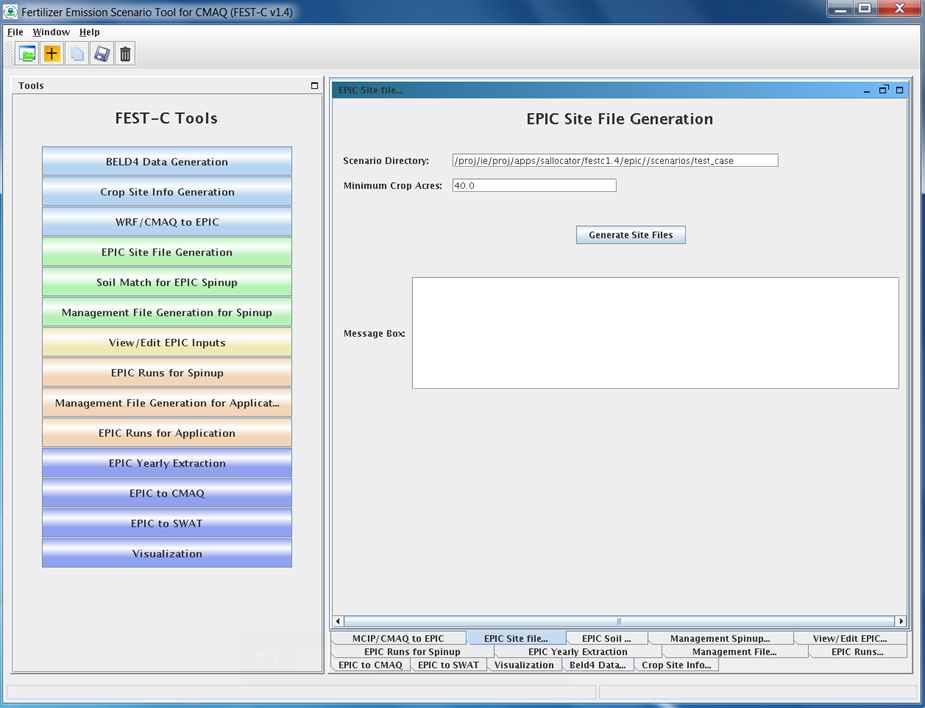
Figure 11. The EPIC Site File Generation interface for the test_case scenario.
After the queue job run has finished, users should check the log file under their scenario’s scripts directory to see whether any errors occurred during execution. The tool generates the following files and directories:
· “scenario name”/share_data/SIT/“GRIDID”0.SIT – EPIC site files to be used for all EPIC crop modeling. A description of the file format can be obtained from the EPIC model documentation.
· “scenario name”/share_data/SITELIST.DAT – EPIC site list file for all crops to be used in EPIC modeling.
· “scenario name”/“crop name”/“crop name”-LIST.DAT – EPIC site list for the particular crop, to be used in the Soil Match for EPIC Spinup tool discussed in the following section. If there are no grid cells that contain that crop, this file will be empty.
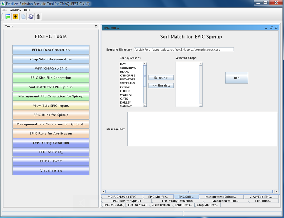
5.2 Soil Match for EPIC Spinup
The Soil Match for EPIC Spinup tool selects a soil for each crop within a grid cell and creates the EPIC soil input file. The EPIC soil datasets are built to represent the sample point soils selected for USDA NRI data points at the HUC-8 spatial scale. This tool links built EPIC soil datasets contained in the BaumerSoils subdirectory to the soil series from the USDA NRI for the crop and grid cell. It uses the FORTRAN programs stored under ${FESTC_HOME}/epic/util /soilMatch with the common data files stored under ${FESTC_HOME}/epic/common_data/ util/soilMatch and the generated soil list data under each crop directory. Figure 12 shows the tool interface used to match soils for all crops (as explained at the beginning of Section 5) for the current version of FEST-C. After selecting the crops, users click the Run button to run the tool in the queue. After the job has finished, users should check the queue job and log file in the “scenario name”/scripts directory, based on the information provided in the Message Box (shown in Figure 12).
The tool generates many output files under each crop directory, but most of them are intermediate files. The final data file created for the EPIC spin-up simulation is “scenario name”/ “crop name”/SOILLIST.DAT, which contains the matched BaumerSoils soil file with other parameters for each grid cell under each crop directory. This step can take substantial time to complete.
Figure
12. The Soil Match for EPIC Spinup tool interface used for the test_case
scenario.
Users can select single or multiple crops for the current FEST-C version.
5.3 Management File Generation for Spinup
The Management File Generation for Spinup tool interface is used to create the EPIC management for each crop within a grid cell. The EPICRUN file that has the linkages for the grid cell, statistical weather and wind files, soil files, and management files is also created for the rain-fed and irrigated forms of the crop. This tool uses the FORTRAN programs ManGenSU.exe and soildrain.exe stored under ${FESTC_HOME}/epic/util/manageCreate with the common data files stored under ${FESTC_HOME}/epic/common_data/util/manageCreate and many other data files generated under each crop directory. Figure 13 shows the tool interface used to generate management files for the test_case scenario.
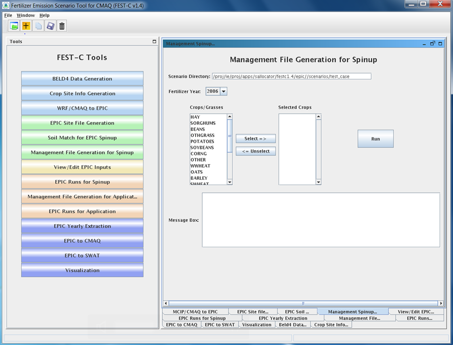
Figure 13. The Management File Generation for Spinup tool used for the test_case scenario.
Users need to make sure that the following two fields are selected correctly:
· Fertilizer Year – select either 2001 or 2006 for choosing the correct common data sets stored under ${FESTC_HOME}/epic/common_data/util/manageCreate. 2011 fertilizer year will be available in future releases. NLCD/MODIS 2011 is available in this release and can be used (e.g. changes in crop fraction) with the 2006 fertilizer year but changes to fertilizer types for 2011 will not be realized in these simulations.
· Selected Crops – select one crop or multiple crops.
After the user clicks the Run button and then “OK”, a queue job to generate management files for each selected crop is submitted. After the job has finished, users should check the queue job and log file in the “scenario name”/scripts directory, based on the information provided in the Message Box (shown in Figure 13).
There are many output files generated under each crop, but many of these are used just for verification. The tool generates the following files to be used for the EPIC spin-up simulations under the directory “scenario name”/“crop name”/spinup/manage for each crop:
· EPICRUNFILERAIN.DAT – EPIC run file for rain-fed spin-up simulation of this crop.
· EPICRUNFILEIRR.DAT – EPIC run file for irrigated spin-up simulation of this crop.
· GRIDS_OPC.DAT – the list of management file names to be used in EPIC modeling.
· OPC/“GRIDID”0“BELD3 Crop Number”.OPC – grid cell EPIC management files under the OPC directory. Table 1 in Section 4.1 lists the crop numbers in the BELD data and how they are mapped, Table 2.
· tileDrain/SOILLIST.DAT – soil list file which contains tile drain information for EPIC simulations and is used when “tileDrain” is selected when running EPIC spinup simulations.
5.4 View/Edit EPIC Inputs
The View/Edit EPIC Inputs interface allows users to view or edit five main EPIC simulation files (listed in Figure 14). Users generally do not need to edit these files, but viewing them can be helpful for debugging. The user has to select a crop first and then select the EPIC simulation type. The simulation type can be SPINUP if the Management File Generation for Spinup tool (previous section) has been executed for the selected crop; or the user can select the simulation type APP after the Management File Generation for Application tool (discussed in Section 6.1) has been executed for the crop. Figure 14 shows the View/Edit EPIC Inputs tool interface for the test_case scenario.
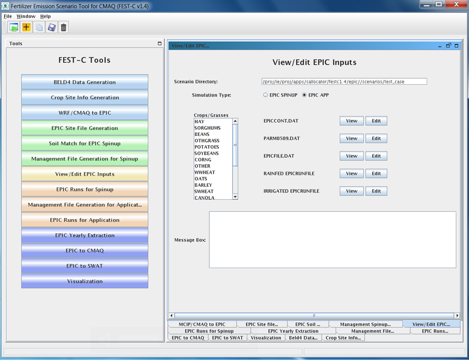
Figure 14. The View/Edit EPIC Inputs tool for the test_case scenario.
5.5 EPIC Runs for Spinup
The EPIC Runs for Spinup tool interface is used to run the EPIC model for spin-up (EPICsu.exe program), which is stored under the directory ${FESTC_HOME}/epic/model/current. The tool uses input files stored primarily in the following directories:
· ${FESTC_HOME}/epic/common_data/EPIC_model/spinup – contains the common model input files.
· scenarios/“scenario name”/share_data – contains site files and list file.
· ${FESTC_HOME}/epic/common_data/statWeath – contains observed climate station statistical data (see http://epicapex.tamu.edu/epic/)
· scenarios/“scenario name”/“crop name”/spinup/manage – contains the run files, management files, and management list file.
· scenarios/“scenario name”/ “crop name” – contains the soil list file.
Spin-up simulations generate EPIC soil files reflecting the user-defined management to be used as initial conditions in the application run for the simulation year. Soil erosion (wind and water) is “turned off” during the spin-up period to avoid loss of productive soil layers. These losses are “turned on” during application year simulation. As discussed in Section 2, the spin-up simulation is run for 25 years starting from 1978 for all crops except potatoes; for potatoes it is run for 100 years starting from 1903. These dates are strictly used for “bookkeeping” and are not used in subsequent steps. Statistically generated weather conditions for Cooperative Observer Weather Stations during the period 1980-2010 drive these simulations. Future releases are expected to support input of alternative sources of long-term weather information (i.e., 25 years or more). Figure 15 displays the tool interface used for the test_case scenario. Users can select one or more crops for the simulation. After clicking the Run button, a script file is generated to run the rain-fed and irrigated EPIC spin-up simulations for each crop. The user submits the script file to the queue by clicking OK. After the job has finished, users should check the queue job and log file in the “scenario name”/scripts directory, based on the information provided in the Message Box (shown in Figure 15).
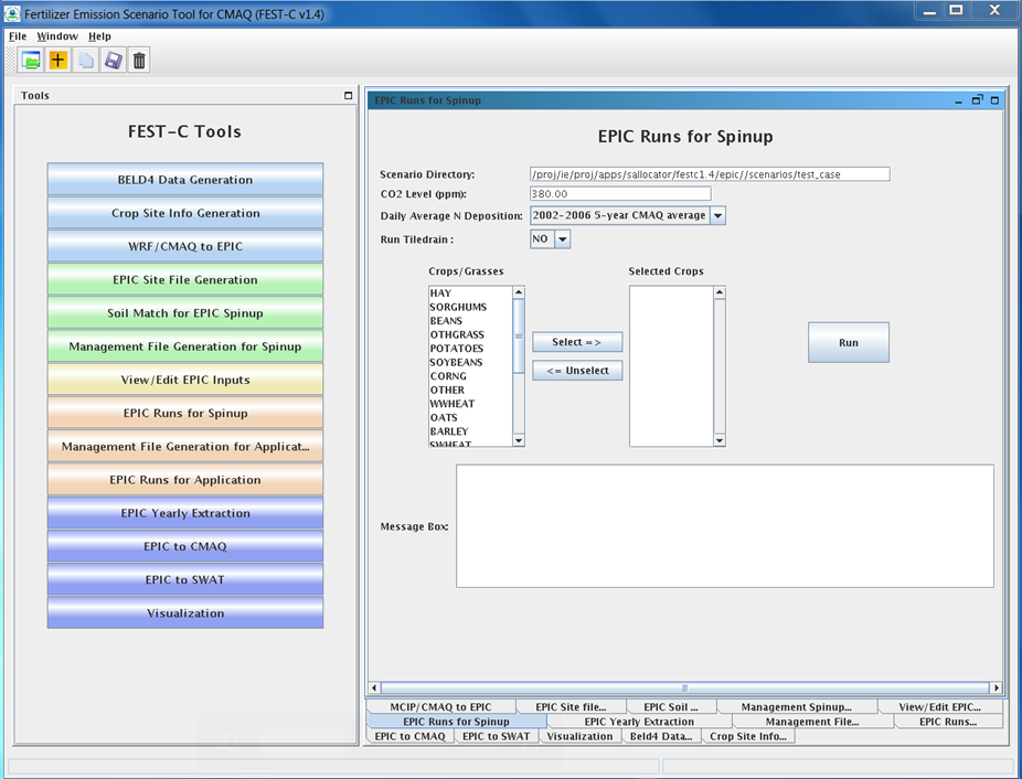
Figure 15. The EPIC Runs for Spinup tool used for the test_case scenario.
Users need to make sure that the following three fields are selected correctly:
· CO2 Level (ppm) - input the correct CO2 level for the simulation (e.g. 380). The input level overwrites the CO2 level defined in EPICCONT.DAT and site file.
· Daily Average N Deposition – select N input to be used in the simulation. Users can select using 1) the values defined in EPIC input files, 2) daily average N input from 5-year CMAQ simulations from 2002 to 2006, or 3) daily average N input from 5-year CMAQ simulations from 2006 to 2010. The 5-year CMAQ N daily input files are stored under ${FESTC_HOME}/epic/common_data/EPIC_model. Future releases will include daily average N input from 5-year CMAQ simulations from 2011 to 2015.
· Run TileDrain – select whether tile drain is applied for saturated soils. If YES is selected, SOILLIST file under scenarios/“scenario name”/“crop name”/spinup/manage/tileDrain will be used. The tile drain process is applied for all crops except hay (1, 2), alfalfa (3, 4), Other_Grass (5, 6) and rice (23, 24).
The tool generates many directories and files for each crop. The original EPIC output files are stored under the two following subdirectories in the “scenario name”/“crop name”/spinup directory:
· rainf – contains output from EPIC rain-fed spin-up simulations for this crop.
· irr – contains output from EPIC irrigated spin-up simulations for this crop.
In both cases, soil files to be used in the EPIC application simulation are:
- SOL/“GRIDID”0“BELD3 Crop Number”.SOL
The output data created for CMAQ modeling are used primarily for QA purposes, and are stored under the following two directories in the “scenario name”/output4CMAQ/spinup directory:
· 5years – contains average EPIC output data from the last five years of the spin-up simulations for the crops.
· daily – stores daily EPIC output data from EPIC spin-up runs for the crops simulated.
6. EPIC Application Run Tools
After users complete the EPIC simulations for spin-up, they can proceed to the EPIC application run tools for the simulation (or application) year. The spin-up simulations need to be run only once for a given domain and grid resolution—in other words, the initial conditions can be re-used for multiple application years. The first step in running an EPIC application is to generate management files for the application year (as described in Section 6.1). The application management program needs to be run only once for a given domain and grid resolution; it is not year-specific. The user can then run the EPIC model for the application year (as described in Section 6.2) if the daily weather and N deposition files for the scenario have already been generated using the tool described in Section 4.3.
6.1 Management File Generation for Application
The Management File Generation for Application tool interface is used to create (1) the EPIC management files for each crop to be used in the EPIC application-year modeling; and (2) the EPICRUN file for the rain-fed and irrigated simulations, which contains the linkages for the statistical weather and wind files, the soil files, and the management files for EPIC grid cells. The tool uses the FORTRAN programs ManGenFERT.exe and soildrain.exe stored under the ${FESTC_HOME}/ epic/util/manageCreate directory with the common data files stored under ${FESTC_HOME} /epic/common_data/util/manageCreate and many other data files generated under each crop directory. Figure 16 shows the tool interface used to generate management files for the test_case scenario. Users must make sure that the following two entries are selected correctly:
· Fertilizer Year – select 2001 or 2006. The common management and fertilizer data sets created under the ${FESTC_HOME}/epic/common_data/util/manageCreate will be used accordingly. This management tool uses the created fertilizer data types for the 10 crop production regions. Fertilizer for 2011 will be available in a future release.
· Selected Crops – select one or more crops.
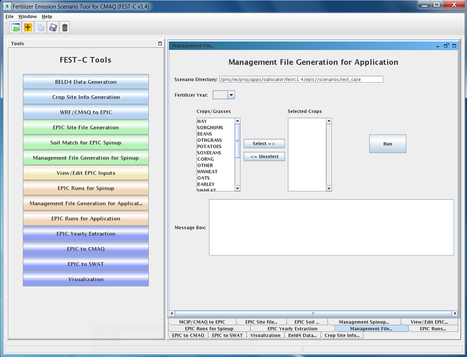
Figure 16. The Management
File Generation for Application tool interface used
for the test_case scenario.
After clicking the Run button, a script file is generated to compute the management files for the selected crops. The user submits the script file to the queue by clicking OK. After the job has finished, users should check the queue job and log file in the “scenario name”/scripts directory, based on the information provided in the Message Box (shown in Figure 16).
The tool will generate many output files under each crop (many of these are used just for verification). The tool generates the following files under the “scenario name”/“crop name”/app/manage directory:
· EPICRUNFILERAINDW.DAT – EPIC run file for rain-fed application simulation.
· EPICRUNFILEIRRDW.DAT – EPIC run file for irrigated application simulation.
· GRIDS_OPC.DAT – the list of management file names to be used in EPIC modeling.
· OPC/“GRIDID”0“BELD3 Crop Number”.OPC – grid cell EPIC management files under the OPC directory. Table 1 in Section 4.1 lists the crop numbers in the BELD data.
· tileDrain/SOILLIST.DAT – soil list file which contains tile drain information for EPIC simulations and is used when “tileDrain” is selected when running EPIC application simulations.
6.2 EPIC Runs for Application
The EPIC Runs for Application tool interface is used to run the EPIC model for the simulation year (EPICapp.exe program), which is stored under the directory ${FESTC_HOME}/epic/ model/current. Users must already have generated the site daily weather and N deposition files using the WRF/CMAQ-to-EPIC tool interface (see Section 4.3). N deposition input can be selected from the four available options – CMAQ, EPIC parameter input file, 2002-2006 5-year CMAQ average, and 2006-2010 5-year CMAQ average. The tool uses input files stored primarily in the following directories:
· ${FESTC_HOME}/epic/common_data/EPIC_model/app – contains the common model input files.
· scenarios/“scenario name”/share_data – contains the EPICCONT.DAT file, site files, site list file, daily weather and N deposition files, and weather list file.
· ${FESTC_HOME}/epic/common_data/statWeath – contains observed climate station statistical data.
· scenarios/“scenario name”/ “crop name” /app/manage – contains the run files, management files, and management list file.
· scenarios/“scenario name”/ “crop name”/spinup/rainf/SOL – contains the soil files to be used in the rain-fed simulations.
· scenarios/“scenario name”/ “crop name”/spinup/irr/SOL – contains the soil files to be used in the irrigated simulations.
Figure 17 shows the tool interface used for the test_case scenario. The Simulation Year is defined when the user creates the scenario. Users can select one or multiple crops for the simulation. After clicking the Run button, a script file is generated to run the rain-fed and irrigated EPIC application simulations for each crop. The EPIC application simulations will run for a two-year period (the previous year and the simulation year) using the same daily weather and N deposition files for the simulation year; the two-year period is needed to simulate a full growing season for fall-sown crops. The user submits the script file to the queue by clicking OK. After the job has finished, users should check the queue job and log file in the “scenario name”/scripts directory, based on the information provided in the Message Box (shown in Figure 17).
Users need to make sure that the following three fields are selected correctly:
· CO2 Level (ppm) - input the correct CO2 level for the simulation (e.g. 380). The input level overwrites the CO2 level defined in EPICCONT.DAT and site file.
· Daily Average N Deposition – select N input to be used in the simulation. Users can select using 1) the CMAQ N values in daily weather files, 2) values defined in EPIC input files, 3) daily average N input from the 5-year CMAQ simulations from 2002 to 2006, or 4) daily average N input from the 5-year CMAQ simulations from 2006 to 2010. The 5-year CMAQ N daily input files are stored under ${FESTC_HOME}/epic/common_data/EPIC_model. Future releases will include daily average N input from 5-year CMAQ simulations from 2011 to 2015.
· Run TileDrain – select whether tile drain is applied for saturated soils. If YES is selected, SOILLIST file under scenarios/“scenario name”/“crop name”/app/manage/tileDrain will be used. The tile drain process is applied for all crops except hay (1, 2), alfalfa (3, 4), Other_Grass (5, 6) and rice (23, 24).
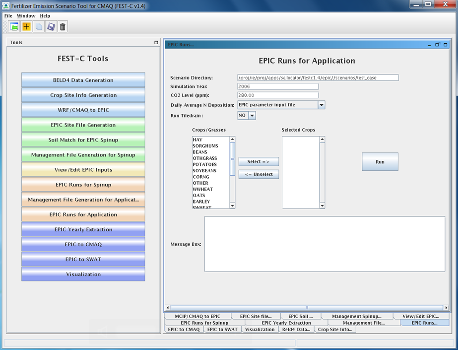
Figure 17. The EPIC Runs for Application tool interface used for the test_case scenario.
The tool generates many directories and files for each crop. The original EPIC output files are stored under the following two subdirectories in the “scenario name”/“crop name”/app directory:
· rainf – contains output from EPIC rain-fed application simulations for this crop.
· irr – contains output from EPIC irrigated application simulations for this crop.
The output data created for CMAQ modeling are stored under the following two subdirectories in the “scenario name”/output4CMAQ/app directory:
· year – contains average EPIC output data for the simulation year (one year) run for the crops simulated. These data are used primarily for QA purposes.
· daily – stores daily EPIC output data from EPIC application runs for the crops simulated. These data are used to extract the input for CMAQ bidirectional NH3 modeling and SWAT simulations.
7. Output Processing and Visualizing Tools
EPIC is a field-based model that generates output in formatted text files. In the domain-based EPIC modeling within FEST-C, the crops in each grid cell are modeled individually. Thus, there are many text output files generated for each crop in each grid cell selected for EPIC modeling. In this section we first describe the EPIC Yearly Extraction tool and the EPIC-to-CMAQ tool. Developed in the SA Raster Tools system, these two tools extract yearly or daily EPIC output variables into NetCDF-format files for QA purposes and for CMAQ modeling. We then discuss the EPIC to SWAT tool which prepares SWAT input files from EPIC output and WRF/CMAQ weather and N deposition NetCDF file using many R codes. The Visualization tool interface, which allows users to prepare spatial views of the EPIC output variables in the created NetCDF files over their modeling scenario domain, is presented last in this section.
7.1 EPIC Yearly Extraction
The EPIC Yearly Extraction tool is used to extract 48 crop-specific variables and 39 crop-area-weighted variables into two NetCDF files from the yearly average EPIC output files for all simulated crops within the grid cells that were selected. The output from this tool is used primarily for QA purposes, to make sure that the EPIC simulation results appear to be spatially reasonable over the domain area. Figure 18 shows the tool interface used for the test_case scenario. The only item users need to select is an “Output Type”:
· EPIC SPINUP – select this to extract yearly average variables from the EPIC spin-up simulations. Yearly average variables from the last five years of the simulations are from the output stored under the “scenario name”/output4CMAQ/spinup/5years directory.
· EPIC APP – select this to extract yearly average variables from the EPIC simulations for the application year. The yearly average variables are from the output stored under the “scenario name”/output4CMAQ/app/year directory.
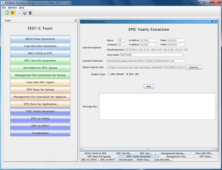
Figure 18. The EPIC Yearly Extraction tool interface used for the test_case scenario.
Table 4 lists all variables that are in the two EPIC output files created by the tool: epic2cmaq_year.nc (crop-specific output) and epic2cmaq_year_total.nc (crop-weighted output). These files are stored in one of the following two directories:
· scenarios/“scenario name”/output4CMAQ/spinup/toCMAQ – if the EPIC SPINUP output type is selected.
· scenarios/“scenario name”/output4CMAQ/app/toCMAQ – if the EPIC APP output type is selected.
Users should check the log file under their scenario’s scripts directory to see whether any errors occurred when the tool was run. If the user is visualizing the data using the VERDI tool for visualization, there is no time dimension. Data layers are assigned to individual crops (see Table 1 in Section 4.1 for the BELD crop numbers).
Table 4. EPIC yearly extraction output variables.
|
epic2cmaq_year.nc - crop specific output |
|
|
|
||
|
Index |
Name |
Variable |
Index |
Name |
Variable |
|
1 |
GMN |
N Mineralized (kg/ha) |
25 |
FTP |
P Applied (kg/ha) |
|
2 |
NMN |
Humus Mineralization (kg/ha) |
26 |
IRGA* |
Irrigation Volume Applied (mm) |
|
3 |
NFIX |
N Fixation (kg/ha) |
27 |
WS |
Water Stress Days (days) |
|
4 |
NITR |
N - Nitrified NH3 (kg/ha) |
28 |
NS |
N Stress Days (days) |
|
5 |
AVOL |
N - Volatilization (kg/ha) |
29 |
IPLD |
Planting Date (Julian Date) |
|
6 |
DN |
N-NO3 Denitrification (kg/ha) |
30 |
IGMD |
Germination Date (Julian Date) |
|
7 |
YON |
N Loss with Sediment (kg/ha) |
31 |
IHVD |
Harvest Date (Julian Date) |
|
8 |
QNO3 |
N Loss in Surface Runoff (kg/ha) |
32 |
YP |
P Loss with Sediment (kg/ha) |
|
9 |
SSFN |
N in Subsurface Flow (kg/ha) |
33 |
QAP |
Labile P Loss in Runoff (kg/ha) |
|
10 |
PRKN |
N Loss in Percolate (kg/ha) |
34 |
YW |
Wind Erosion (ton/ha) |
|
11 |
FNO |
N - Organic Fertilizer (kg/ha) |
35 |
Q* |
Runoff (mm) |
|
12 |
FNO3 |
N - Nitrate Fertilize (kg/ha) |
36 |
SSF |
Subsurface flow (mm) |
|
13 |
FNH3 |
N - Ammonia Fertilize (kg/ha) |
37 |
PRK |
Percolation (mm) |
|
14 |
OCPD |
Organic Carbon in Plow Layer (mt/ha) |
38 |
PRCP |
Rainfall (mm) |
|
15 |
TOC |
Organic Carbon in Soil Profile (mt/ha) |
39 |
PET |
Potential Evapotranspiration (mm) |
|
16 |
TNO3 |
Total NO3 in Soil Profile (kg/ha) |
40 |
ET |
Evapotranspiration (mm) |
|
17 |
DN2 |
N-N2O from NO3 Denitrification (kg/ha) |
41 |
QDRN |
Drain Tile Flow (mm) |
|
18 |
YLDG |
Grain Yield (t/ha) |
42 |
MUSL |
Water erosion (ton/ha) |
|
19 |
T_YLDG |
T - Grain Yield (1000ton) |
43 |
DRNN |
Nitrogen in drain tile flow (kg/ha) |
|
20 |
YLDF |
Forage Yield (t/ha) |
44 |
DRNP |
P in Drain Tile Flow (kg/ha) |
|
21 |
T_YLDF |
T - Forage Yield (1000ton) |
45 |
PRKP |
P in Percolation (kg/ha) |
|
22 |
YLN |
N Used by Crop (kg/ha) |
46 |
FPO |
Organic P Fertilizer (kg/ha) |
|
23 |
YLP |
P Used by Crop (kg/ha) |
47 |
FPL |
Labile P Fertilizer (kg/ha) |
|
24 |
FTN |
N Applied (kg/ha) |
48 |
MNP |
P Mineralized (kg/ha) |
|
|
|
|
|
|
|
|
epic2cmaq_year_total.nc - crop weighted output |
|
|
|
||
|
Index |
Name |
Variable |
Index |
Name |
Variable |
|
1 |
T_GMN |
N Mineralized (mt - metric ton) |
21 |
T_FTP |
P Applied (mt) |
|
2 |
T_NMN |
Humus Mineralization (mt) |
22 |
T_IRGA* |
Irrigation Volume Applied (mm) |
|
3 |
T_NFIX |
N Fixation (mt) |
23 |
T_YP |
T - P Loss with Sediment (mt) |
|
4 |
T_NITR |
N - Nitrified NH3 (mt) |
24 |
T_QAP |
T - Labile P Loss in Runoff (mt) |
|
5 |
T_AVOL |
N - Volatilization (mt) |
25 |
T_YW |
T - Wind Erosion (1000ton) |
|
6 |
T_DN |
N-NO3 Denitrification (mt) |
26 |
T_Q* |
T - Runoff (mm) |
|
7 |
T_YON |
N Loss with Sediment (mt) |
27 |
T_SSF |
T - Subsurface flow (mm) |
|
8 |
T_QNO3 |
N Loss in Surface Runoff (mt) |
28 |
T_PRK |
T - Percolation (mm) |
|
9 |
T_SSFN |
N in Subsurface Flow (mt) |
29 |
T_PRCP |
T - Rainfall (mm) |
|
10 |
T_PRKN |
N Loss in Percolate (mt) |
30 |
T_PET |
T - Potential Evapotranspiration (mm) |
|
11 |
T_FNO |
N - Organic Fertilizer (mt) |
31 |
T_ET |
T - Evapotranspiration (mm) |
|
12 |
T_FNO3 |
N - Nitrate Fertilizer (mt) |
32 |
T_QDRN |
T - Drain Tile Flow (mm) |
|
13 |
T_FNH3 |
N - Ammonia Fertilizer (mt) |
33 |
T_MUSL |
T - Water erosion (ton/ha) |
|
14 |
T_OCPD |
Organic Carbon in Plow Layer (1000mt) |
34 |
T_DRNN |
T – N in drain tile flow (kg/ha) |
|
15 |
T_TOC |
Organic Carbon in Soil Profile (1000mt) |
35 |
T_DRNP |
T - P in Drain Tile Flow (kg/ha) |
|
16 |
T_TNO3 |
Total NO3 in Soil Profile (mt) |
36 |
T_PRKP |
T - P in Percolation (kg/ha) |
|
17 |
T_DN2 |
N-N2O from NO3 Denitrification (mt) |
37 |
T_FPO |
T - Organic P Fertilizer (kg/ha) |
|
18 |
T_YLN |
N Used by Crop (mt) |
38 |
T_FPL |
T - Labile P Fertilizer (kg/ha) |
|
19 |
T_YLP |
P Used by Crop (mt) |
39 |
T_MNP |
T - P Mineralized (kg/ha) |
|
20 |
T_FTN |
N Applied (mt) |
|
|
|
*Water on agricultural lands.
7.2 EPIC to CMAQ
The EPIC to CMAQ tool is used to extract 13 variables from EPIC soil output files and 41 variables from EPIC daily output files into NetCDF files for all simulated crops within the grid cells that were selected. The output from this tool is used as input to CMAQ bidirectional NH3 modeling over the domain area. Figure 19 shows the tool interface used for the test_case scenario.
The user needs to input the following two items:
· Output File Prefix – this is used as the file prefix for all of the NetCDF output file names
· Output Type – select “EPIC SPINUP” to extract yearly average variables from the EPIC spin-up simulations under the “scenario name”/output4CMAQ/spinup/5years directory and “EPIC APP” to extract yearly average variables from the EPIC simulations for the application year under the “scenario name”/output4CMAQ/app/year directory.
The following output files produced by the tool are stored under the scenarios/“scenario name”/output4CMAQ/app/toCMAQ directory:
· “Output File Prefix”_soil.nc – soil output file that contains 13 soil variables extracted from the EPIC soil output files (“scenario name”/output4CMAQ /app/daily/“BELD4 Crop Number”.NCS); these variables are listed in Table 5. L1 and L2 are for the soil depth from 0 to 1 cm and from 1 cm to 10 cm, respectively.
· “Output File Prefix”_timeYYYYMMDD.nc – daily NetCDF files for the simulation year. A daily NetCDF file contains 41 variables extracted from the EPIC daily output files (e.g. “scenario name”/output4CMAQ /app/daily/“BELD4 Crop Number”.NCD”); these variables are listed in Table 6. L1, L2, and T1 are for the soil depth from 0 to 1 cm, from 1 cm to 10 cm, and from 0 cm to the full Baumer soil profile depth, which can be more than 1 m.
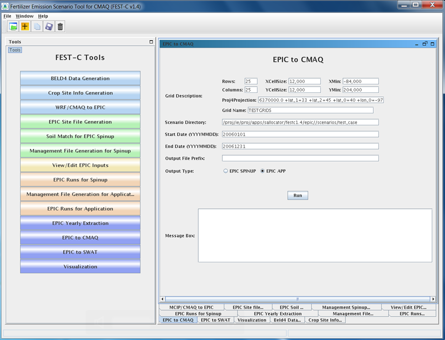
Figure 19. The EPIC to CMAQ tool interface used for the test_case scenario.
Table 5. EPIC to CMAQ soil output variables
|
Index |
Name |
Soil Variable |
Index |
Name |
Soil Variable |
|
1 |
L1_SoilNum |
Soil Number (none) |
8 |
L2_Bulk_D |
Layer2 Bulk Density (t/m**3) |
|
2 |
L1_Bulk_D |
Layer1 Bulk Density (t/m**3) |
9 |
L2_Wilt_P |
Layer2 Wilting Point (m/m) |
|
3 |
L1_Wilt_P |
Layer1 Wilting Point(m/m) |
10 |
L2_Field_C |
Layer2 Field Capacity (m/m) |
|
4 |
L1_Field_C |
Layer1 Field Capacity (m/m) |
11 |
L2_Porosity |
Layer2 Porosity (%) |
|
5 |
L1_Porosity |
Layer1 Porosity (%) |
12 |
L2_PH |
Layer2 PH (none) |
|
6 |
L1_PH |
Layer1 PH (none) |
13 |
L2_Cation |
Layer2 Cation Ex (cmol/kg) |
|
7 |
L1_Cation |
Layer1 Cation Ex (cmol/kg) |
|
|
|
Table 6. EPIC to CMAQ daily output variables
|
Index |
Name |
Variable |
Index |
Name |
Variable |
|
1 |
DN |
N-NO3 Denitrification (kg/ha) |
22 |
L2_NH3 |
Layer2 N - Ammonia (kg/ha) |
|
2 |
DN2 |
N-N2O from NO3 Denitrification (kg/ha) |
23 |
L2_ON |
Layer2 Organic N (kg/ha) |
|
3 |
HMN |
OC Change by Soil Respiration (kg/ha) |
24 |
L2_C |
Layer2 Carbon (kg/ha) |
|
4 |
NFIX |
N Fixation (kg/ha) |
25 |
L2_NITR |
Layer2 N - Nitrified NH3 (kg/ha) |
|
5 |
GMN |
N Mineralized (kg/ha) |
26 |
T1_DEP |
Layert Depth (m) |
|
6 |
YW |
Wind Erosion (ton/ha) |
27 |
T1_BD |
Layert Bulk Density (t/m**3) |
|
7 |
FPO |
Organic P Fertilizer (kg/ha) |
28 |
T1_NO3 |
Layert N - Nitrate (kg/ha) |
|
8 |
FPL |
Labile P Fertilizer (kg/ha) |
29 |
T1_NH3 |
Layert N - Ammonia (kg/ha) |
|
9 |
MNP |
P Mineralized (kg/ha) |
30 |
T1_ON |
Layert Organic N (kg/ha) |
|
10 |
L1_DEP |
Layer1 Depth (m) |
31 |
T1_C |
Layert Carbon (kg/ha) |
|
11 |
L1_BD |
Layer1 Bulk Density (t/m**3) |
32 |
T1_NITR |
Layert N - Nitrified NH3 (kg/ha) |
|
12 |
L1_SW |
Layer 1 Soil Moisture (mm) |
33 |
L1_ANO3 |
Layer1 N-NO3 AppRate (kg/ha) |
|
13 |
L1_NO3 |
Layer1 N - Nitrate (kg/ha) |
34 |
L1_ANH3 |
Layer1 N-NH3 AppRate (kg/ha) |
|
14 |
L1_NH3 |
Layer1 N - Ammonia (kg/ha) |
35 |
L1_AON |
Layer1 ON AppRate (kg/ha) |
|
15 |
L1_ON |
Layer1 Organic N (kg/ha) |
36 |
L2_ANO3 |
Layer2 N-NO3 AppRate (kg/ha) |
|
16 |
L1_C |
Layer1 Carbon (kg/ha) |
37 |
L2_ANH3 |
Layer2 N-NH3 AppRate (kg/ha) |
|
17 |
L1_NITR |
Layer1 N - Nitrified NH3 (kg/ha) |
38 |
L2_AON |
Layer2 ON AppRate (kg/ha) |
|
18 |
L2_DEP |
Layer2 Depth (m) |
39 |
LAI |
Leaf Area Index (none) |
|
19 |
L2_BD |
Layer2 Bulk Density (t/m**3) |
40 |
CPHT |
Crop Height (m) |
|
20 |
L2_SW |
Layer 2 Soil Moisture (mm) |
41 |
FBARE |
Bare Land Fraction for Wind Erosion (Fraction) |
|
21 |
L2_NO3 |
Layer2 N - Nitrate (kg/ha) |
|
|
|
|
Note: EPIC is a daily time step model while the CMAQ bidirectional NH3 flux model is at a time scale which could be less than 10 minutes. |
|||||
When the user clicks the Run button, a script file is generated under the scenario’s scripts directory. The script file is submitted to the queue for execution after the user clicks OK. A CMAQ-ready file is generated for each day and is viewable in VERDI. After the queue job has completed, users should check the log file under the scripts directory to see whether any errors occurred during execution.
7.3 EPIC to SWAT
The EPIC to SWAT tool is used to extract EPIC output and WRF/CMAQ weather and N deposition data for SWAT simulations in 8-digit HUC watersheds defined by users. “EPIC”, “NDEP”, and “DailyWETH” are tools which users can click in any order to aggregate EPIC daily output and N deposition and weather data in CMAQ grid format into the different areas listed. After aggregated EPIC, N deposition, and weather files are created, users can click “SWAT INPUTS” to generate SWAT-ready input files. The output from “SWAT INPUTS” can be used by SWAT modelers to replace default or “traditional” SWAT weather, atmospheric deposition and agricultural land nutrient and runoff input. Figure 20 shows the tool interface which is used for the test_case scenario. Users need to make sure that the following fields are filled and selected correctly:
· HUC8 Delivery Ratio File – EPIC to SWAT integration file. This text file contains SWAT 8-digit HUC watershed information with average delivery ratios from EPIC edge-of-field output to SWAT watershed output. Users can view the delivery ratio file – “test_case/share_data/subbasins-mapping_test_case.csv” included for the test_case scenario for items and format required.
· Daily Average N Deposition – select the source of N deposition for SWAT extraction. Users can select CMAQ application year N deposition or one of the 5-year average CMAQ N deposition.
· Area Selection – select area for generating SWAT-ready input files by the “SWAT INPUTS” button. The current system only works for 8-digit HUC SWAT input file generation regardless of which area is selected. The “EPIC”, “NDEP”, and DailyWETH” extraction buttons will generate aggregated data for all areas listed.
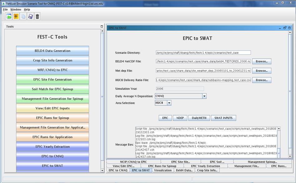
Figure 20. The EPIC to SWAT interface.
The button tools with descriptions in this subinterface are:
Table 7. Conversion of EPIC daily output to SWAT point source input
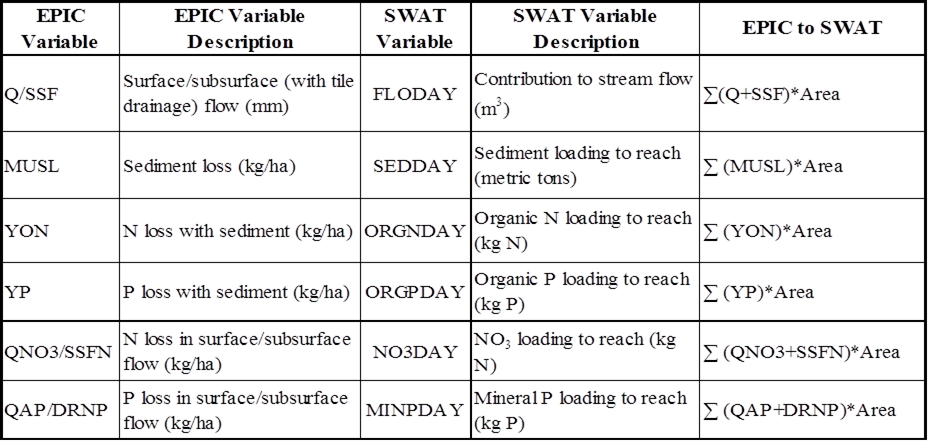
Notes: Area is for the crop area in a specific grid. ∑ is the summation for all grids in a region (e.g. HUC8).
· NDEP - aggregate daily N deposition variables required by SWAT (Table 8) from daily deposition NetCDF file generated from CMAQ to all areas listed on the interface (Domain, State, County, HUC8, HUC6, and HUC2). This tool uses the R program epic2swat_extract_daily_ndepCMAQ.R stored under ${FESTC_HOME}/epic/util/swat. After clicking the NDEP button, a script file is generated to run the program using all information defined by environment variables. The user submits the script file to the queue by clicking OK. After the job is finished, users should check the queue job and log file in the “scenario name”/scripts directory, based on the information provided in the Message Box (shown in Figure 20). The output files from the tool are stored under the sub-directories with corresponding area names in the “scenario name”/output4SWAT/NDEP directory.
Table 8. CMAQ N Deposition to SWAT
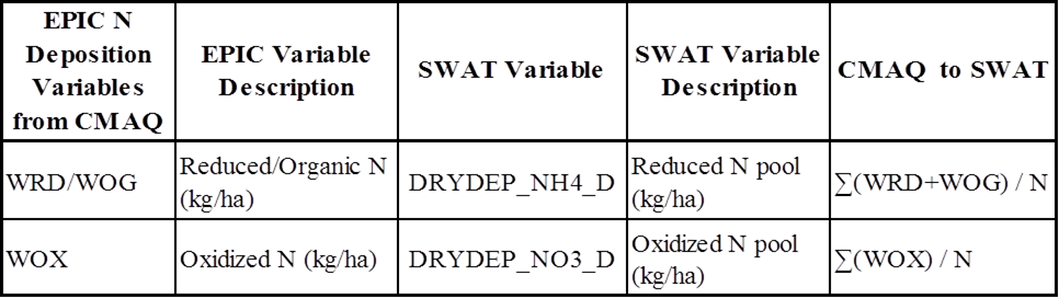
Note: N is the total number of grid cells in a specific region (e.g. HUC8).
· DailyWETH - aggregate daily weather variables required by SWAT (Table 9) from daily weather NetCDF file generated from WRF to all areas listed on the interface (Domain, State, County, HUC8, HUC6, and HUC2). This tool uses the R program epic2swat_extract_daily_metCMAQ.R stored under ${FESTC_HOME}/epic/util/swat. After clicking the DailyWETH button, a script file is generated to run the program using all information defined by environment variables. The user submits the script file to the queue by clicking OK. After the job is finished, users should check the queue job and log file in the “scenario name”/scripts directory, based on the information provided in the Message Box (shown in Figure 20). The output files from the tool are stored under the sub-directories with corresponding area names in the “scenario name”/output4SWAT/dailyWETH directory.
Table 9. WRF daily weather to SWAT
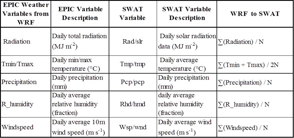
Note: N is the total number of grid cells in a specific region (e.g. HUC8).
· SWAT INPUTS – generate SWAT-ready input files from aggregated daily EPIC, weather, and N deposition files by the previous three button tools for the watersheds specified in the “HUC8 Delivery Ratio File” field. This tool calls the R program extract_swatInputs.R stored under ${FESTC_HOME}/epic/util/swat. After clicking the “SWAT INPUTS” button, a script file is generated to run the program using all information defined by environment variables. The user submits the script file to the queue by clicking OK. After the job is finished, users should check the queue job and log file in the “scenario name”/scripts directory, based on the information provided in the Message Box (shown in Figure 20). The output files from the tool are stored under the sub-directories for EPIC, weather, and N deposition individually in the “scenario name”/output4SWAT/swat_inputs directory.
7.4 Visualization
The Visualization tool interface is used to invoke the VERDI interface to view a selected NetCDF data set. Figure 21 shows the appearance of the tool interface before an input file has been selected. Users can select the data type on the left side of the interface window and then by browse through the file systems to select a NetCDF file created or used within the FEST-C system (e.g., an EPIC output NetCDF file created by the previous two tools, a BELD4 data set, MCIP and CMAQ data sets, a daily weather and N deposition NetCDF output file). Clicking the Display button invokes the VERDI interface to visualize the selected NetCDF file. Note: For this to work properly, the user has to have set the VERDI system in the FEST-C configuration file config.properties (see Section 1.3). Information on how to use the VERDI system can be obtained from the CMAS VERDI site: http://www.cmascenter.org/verdi/.
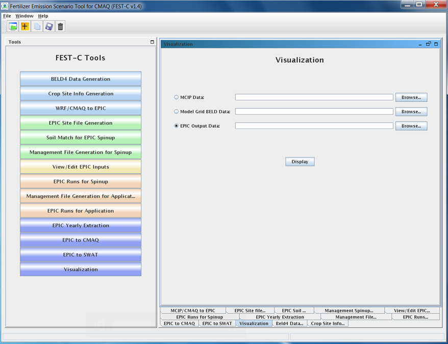
Figure 21. The Visualization tool interface.
8. Future Work
In this release, 2011 NLCD/MODIS data is available to produce crop fractions for Canada and the US. To accompany this data, a future release will include an updated fertilizer type scenario for 2011. In addition, we will continue to improve the crop fraction coverage with the upcoming NLCD 2016 release using the USDA 2017 census data and corresponding crop census data for Canada and Mexico. We are continuing our efforts to improve the C-N-P budgets within this systems for different crops. We are also exploring the possibility of moving to computing crop land use data directly from USDA National Agricultural Statistics Service (NASS) Cropland Data Layer (CDL) data. This would provide higher-resolution crop spatial information, however, CDL data do not include some information that is critical for FEST-C EPIC (such as differentiation between irrigated and rain-fed crops). Thus, further exploration on using this data set in combination with other irrigation data is needed.