Community Modeling and Analysis System
VERDI
PAVE or VERDI?
How do you know if you should use PAVE or VERDI?
VERDI was developed as a replacement for the PAVE program. Because PAVE is no longer in active development and support is limited, VERDI offers the best option as a state-of-the-art visualization program.
Visualize gridded netCDF data with this easy-to-use Java program.
VERDI is a Java program for visualizing meteorology, emissions, and air quality modeling data. With options for overlaying GIS Shapefiles and observational data onto model output, VERDI offers a range of options for viewing atmospheric modeling data. VERDI scripting provides a powerful interface for automating the production of graphics for analyzing your data.
Features:
Java
VERDI uses Java, which makes it easy to install and is portable across different operating systems.
VERDI packages are distributed for 64-bit Windows, Linux, and Mac.
GUI
The VERDI user environment is an intuitive GUI that makes importing datasets, creating formulas, and generating and saving plots easy.
Supported Plot Types
VERDI currently can be used to create 2-D tile plots, vertical cross sections, scatter plots, timeseries line, timeseries bar, 3-D contour plots, vector-tile plots, areal interpolation plots, and observation-tile plots.
Supported File Format Conventions
CMAQ Input/Output Applications Programming Interface (I/O API) netCDF, WRF netCDF, MPAS netCDF, CAMx (UAM-IV), and I/O API and text-based ASCII formats (for observational data).
Scriptable
VERDI can be driven with a scripting language to allow batch-generation of images.
VERDI 2.2 Updates
The following new feature was added:
- Added ability to add Satellite Image Layer using the OpenTopoMap as the tile provider.
- Enabled option to choose layer ranges with two or more datasets in the Formula Panel (#356)
- Updated the java library to support remote file transfers on secure ssh servers. Apache Mina SSHD
The following issues were fixed:
- The error associated with layer_sum/layer_mean tile plots for unconventional 3D variables (#352)
- Incorrect maximum value in tile plot legend when load a configuration file with a logarithmic scale (#353)
- Unable to choose layer ranges with two or more datasets in the Dataset Panel (#356)
VERDI 2.1.6 Updates
Updated netCDF-Java to version 5.5.3 (https://github.com/Unidata/netcdf-java/releases/tag/v5.3.3)
The following new features were added:
- Visualize differences between time-independent model files (#341)
- Reading netCDF files with unconventional dimension names (#344)
- Calculate layer (sum and mean) statistics for all layers or a subset of layers chosen in the dataset panel followed by creation of a new tile plot. (#345)
The following issues were fixed:
- Incorrect values for probed grid cells for statistics "maximum 8hr mean" in tile plot (#325)
- Batch script does not turn off column/row labels and legends as specified in the configuration file (#347)
VERDI 2.1.5 Updates
Updated OpenJDK to version java 21.0.1 2023-10-17 LTS to fix security vulnerability.
The following new features were added:
- Open and display a MPAS Mesh File (#324)
- Documentation on how to visualize fine scale model output datafiles with GIS layers
- Support sub-domain on a Vertical Cross Section Plot from the command line (#326)
The following issues were fixed:
- Save tile plot as shapefile from GUI (#322)
- MPAS scatterplot tool from GUI (#255)
- Saving and Opening a Project (#318)
- Read zgrid variable from MPAS using VERDI CLI (#257)
The following enhancement was made (#200):
- VERDI saves color values using six digit hex color codes to a saved configuration file and reads configure files using either 32 bit integer codes or the hex color codes.
The following features were depreciated
- Disabled Domain Window including "Metadata Me" (#320)
VERDI 2.1.4 Updates:
- Ability to display 3-D contour plot (#184, #304)
- Ability to display zgrid tile plot for MPAS dataset (#257)
- Allow user to modify scatter plot dot size (#260) Allow animate plot to be exported as .mp4 movie format (#270)
- Fix Tile Plot Legend Placement (#307)
- Allow tabbed panes that were closed to be reopened (#285)
Updated OpenJDK to version 17.0.2 to fix security vulnerability: https://openjdk.java.net/groups/vulnerability/advisories/2021-10-19
VERDI 2.1.3 Updates:
- Note, the User Manual for VERDI has not been updated. It will be updated for the next Major Release.
Update log4j 2.17.1 to fix security vulnerability: https://logging.apache.org/log4j/2.x/index.html
VERDI 2.1.2 Updates:
- Fixed linux build to use openjdk 16.0.2 2021-07-20.
- Re-enabled the splash screen with automatic version numbering.
- Note, the User Manual for VERDI has not been updated. It will be updated for the next Major Release.
Update log4j 2.17 to fix security vulnerability: https://logging.apache.org/log4j/2.x/index.html
VERDI 2.1.1 Updates:
- Fixed Polar Stereographic Projection Issue for Tile Plot Display of WRF Files.
Hot Patch for VERDI with log4j 2.0.16 to remove message lookup capability to eliminate the log4shell security vulnerability: https://logging.apache.org/log4j/2.x/security.html
VERDI 2.1 Updates
- Enhanced user interface and interactive features related to observation overlays (e.g., preview feature, custom symbols)
- Added support for setting legend levels from a batch script.
- Improved error messaging (when an observation data set does not contain data for the map being shown).
- Updated Java Runtime Environment to OpenJDK 16.02
History of VERDI
Driven by the air quality modeling community's need for a replacement to PAVE, the U.S. EPA sponsored the development of VERDI. PAVE is a Unix-based software system written in C and Motif. While the EPA is satisfied with the functionality of PAVE and desired to keep those capabilities, they recognize that the PAVE technology is outdated and wanted an updated, more efficient, flexible, and modular visualization software system. Argonne National Laboratory initially developed VERDI to duplicate the functionality of PAVE in a Java program. VERDI development continues thanks to the efforts of the U.S. EPA's National Computer Center/Environmental Modeling and Visualization Laboratory and the Institute for the Environment at the University of North Carolina - Chapel Hill.
Latest Version: VERDI version 2.2
**REPLACE ALL PRIOR** versions of VERDI with this release version.
DOWNLOAD | DOCUMENTATION
VERDI Training
Support
Previous Documentation
Online Resources
- A New Tool for Analyzing CMAQ Modeling Results: Visualization Environment for Rich Data Interpretation (VERDI) - presented by Donna Schwede at the 2007 CMAS Conference.
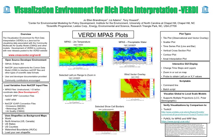
- Visualization Environment for Rich Data Interpretation - VERDI - poster presented by Jo Ellen Brandmeyer and Elizabeth Adams at the 2016 CMAS Conference.
System Requirements
| O/S | Windows, Linux, Mac |
| Memory | 1024 MB RAM |
| Software | All needed VERDI components are contained in the distribution package. |
Partners
Community Modeling and Analysis System (CMAS)
General inquiries about the CMAS Center and questions about the web site should be directed to cmas@unc.edu